Category 4 Cyclone Kenneth crashes ashore in Mozambique – Thousands evacuated as Mozambique is hit with the strongest storm in its history
By Bob Henson
25 April 2019
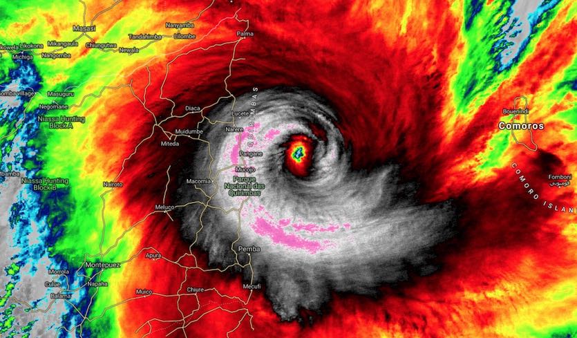
(Weather Underground) – Tropical Cyclone Kenneth slammed onto the coast of far northern Mozambique around 4 pm Thursday afternoon local time (10:15 am EDT) as a potentially catastrophic Category 4 storm. Just before landfall, at 12Z (8 am EDT), Kenneth’s top sustained winds were pegged at 120 knots (140 mph)—solidly in the Cat 4 range—by the Joint Typhoon Warning Center. The agency issuing the official forecasts for the South Indian Ocean, RSMC-La Reunion, put Kenneth’s top winds at 12Z at 110 knots (125 mph), but this is a 10-minute average, a value tends to run slightly lower than the 1-minute average used by JTWC and by the U.S. National Hurricane Center.
The cyclone made landfall at the northern end of Mozambique’s Quirimbas National Park, a thinly populated area but with a number of villages with no experience of a storm of this magnitude. The stronger southern side of Kenneth’s eyewall was focused in this region. The Quisanga Islands, which includes several resorts, were likely quite hard hit by Kenneth’s winds and by a storm surge that could have been as high as 3 -5 meters (10 – 16 feet), according to RSMC-La Reunion.
Kenneth has been a very compact cyclone, which facilitated its rapid growth from tropical storm to Category 4 strength in just 36 hours. As Kenneth approached the coast, its hurricane-force winds extended only about 40-45 miles to the south and 30-35 miles to the north. At the city of Pemba, about 60 miles south of where Kenneth made landfall, top sustained winds at the time were only about 27 mph, with gusts to 39 mph.
NOAA’s HWRF model did an especially impressive job of predicting Kenneth’s rapid intensification. More than two days in advance, HWRF was consistently calling for Kenneth to hit Category 4 strength in the 24 hours before landfall.
On Wednesday, Kenneth swept past the northern end of the Comoros Islands, with its southern eyewall passing over Grande Comore, the largest of the islands. Trees and power lines were downed, and several shacks destroyed, according to AFP. At least three deaths have been attributed to the storm, according to Reuters.
An unprecedented event for northern Mozambique
In records going back 50 years, far northern Mozambique has no record of storms of even minimal hurricane strength, much less a system as powerful as Kenneth. The landfall location (12°S) is quite close to the equator, in a latitude range where it becomes more difficult for cyclones to gather enough atmospheric spin to develop. Only a couple of tropical depressions and tropical storms have made landfall this far north in Mozambique or in Tanzania in the several decades of satellite coverage.
Kenneth ranks among the strongest landfalls on record for the entire African mainland. Cyclone Leon-Eline struck Madagascar on Feb. 26, 2000, with top one-minute sustained winds of 134 mph as assessed by JTWC. Off the mainland, Cyclones Hary (2000) and Gafilo (2004) both struck Madagascar at Category 5 strength, with top sustained winds of 160 mph, according to JTWC.
Kenneth is smaller but more intense than Tropical Cyclone Idai, which made a catastrophic landfall in central Mozambique near the city of Beira on 15 March 2019. Idai peaked offshore as a Category 3 storm—with top sustained winds of 120 mph, according to JWTC—and made landfall as a Category 2 with top winds of 105 mph. In modern satellite-era records, Mozambique has never recorded two Cat 2 or stronger landfalls in the same year. [more]
Category 4 Kenneth Crashes Ashore in Mozambique; Devastating Rains Still to Come
Cyclone Kenneth: Thousands evacuated as Mozambique is hit with the strongest storm in its history
By Brandon Miller and Bukola Adebayo
25 April 2019
(CNN) – Thousands of people were being evacuated to shelters Thursday as powerful Tropical Cyclone Kenneth bore down on northern Mozambique.
The storm had maximum sustained winds of 220 kph (140 mph) — the equivalent of a Category 4 hurricane.
Kenneth comes a little more than a month after the country was dealt a devastating blow by the deadliest and costliest storm in its history — Tropical Cyclone Idai.
Kenneth is the strongest tropical cyclone to hit Mozambique in known history.
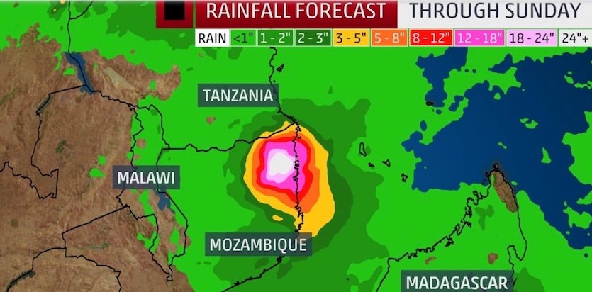
The National Institute of Disaster Management in Mozambique said it had provided shelters and begun “compulsory evacuation” of families to the shelters.In addition to the dangerous winds and storm surge, Kenneth will bring torrential rainfall and significant flooding. More than 20 inches of rain is projected over the next four days — roughly four times the average monthly rainfall for the region.
Kenneth strengthened rapidly Wednesday and continued to intensify Thursday morning. Landfall was expected approximately 1,000 kilometers (620 miles) north of where Idai struck. [more]
Cyclone Kenneth: Thousands evacuated as Mozambique is hit with the strongest storm in its history