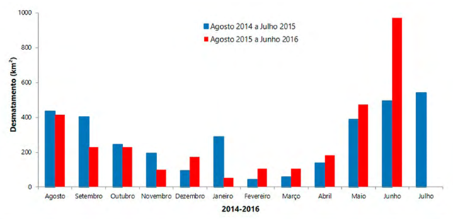
June deforestation in Brazilian Amazon doubled over same period in 2015
[Translation by Bing Translator.] 22 July 2016 (Imazon) – In June 2016, SAD detected 972 square kilometers of deforestation (the total destruction of forest for other alternative uses of the soil) in the Amazon, with a cloud coverage of 16% of the territory. This represented an increase of 97% over June 2015 when deforestation amounted to 494 square kilometers and the cloud cover was 15%. In June 2016, deforestation concentrated in Pará (50%), Amazonas (27%), Mato Grosso (12%) and Rondônia (9%), with minor occurrence in Roraima (1%) and Acre (1%). The accumulated deforestation in the period of August 2015 to June 2016, corresponding to the first eleven months the official calendar for measurement of deforestation, hit 3,040 square kilometers. There was an increase of 9% of the deforestation in relation to the previous period (August 2014 to June 2015) when it reached 2,780 square kilometers. Considering the 11 first months of the current calendar (August 2015 to June 2016), Pará leads the ranking with 32% of the total deforested during the period, followed by Mato Grosso (28%) and Amazonas (22%). In relative terms, there was a reduction of 68% in Acre and 31% in Roraima. In absolute terms, the Pará leads the ranking of deforestation with 966 square kilometers, followed by Mato Grosso (837 square kilometres ) and Amazonas (682 square kilometres). [more]
Boletim do desmatamento da Amazônia Legal (junho de 2016) SAD
