Record Louisiana floods continue into fifth day
By Emily Wagster Pettus
12 March 2016 HATTIESBURG, Mississippi (AP) – As the Leaf River rose north of Hattiesburg, Mississippi, 26-year-old Rebecca Bruce and her fiancé grabbed what they could and left the shed where they live. The water was more than 2 feet deep indoors when they left, she said. “We lost everything,” Bruce said Saturday. “I’ve got a book bag full of dirty clothes, and I was lucky to get that.” Bruce was among about 20 people in a Red Cross shelter in the Forrest County Community Center on Saturday, as creeks and rivers continued to rise after torrential rains pounded the Deep South. Downpours — part of a system affecting Louisiana, Mississippi, Arkansas, Tennessee and Alabama — submerged roads and cars, washed out bridges and forced residents to flee homes. At least three people have died in Louisiana alone. Mississippi officials were still looking for two missing fishermen, but had no reports of injuries or deaths, Lee Smithson, head of the Mississippi Emergency Management Agency, said Saturday. A Hancock County sheriff’s deputy was hospitalized after his patrol car skidded into a ditch Friday night, but is now recovering at home, Chief Deputy Don Bass told the Sun Herald (http://bit.ly/1RGmhdZ ). [more]
Unusually widespread flooding across Louisiana, Mississippi
By David Begnaud
11 March 2016 BOSSIER CITY, Louisiana (CBS News) – Record floods that have killed at least five people in the South are not letting up as torrential rains continue into a fifth day. As of late Friday afternoon, the Red Chute Bayou water level was 25 feet and rising. The water rushing downstream from two lakes to the north had made Bossier City Ground Zero. The Red Chute Bayou was in danger of topping the city’s main levee and 3,500 homes were at risk of flooding — both to its west and to its south. Because of recent heavy rains, approximately 30,000 gallons of water were flowing downstream each second — seven to 10 times the normal flow. Sandbags were being dropped to protect the levee from eroding if water tops it. Mike Petersen is with the U.S. Army Corps of Engineers. He characterized the area as a choke point, where all the water is forced through a relatively narrow area. That’s why it is rising so quickly, about 10 feet in three days, two feet in last day alone. Firefighter Josh Wolverton has been rescuing people for two days. Now, his home is at risk. He says the levee is about 300-400 yards from his backyard. “We’ve lived here for six years. I’ve never seen water in the streets. Never,” he said. Since then, he’s evacuated his wife and daughters and elevated his furniture using canned goods to prop them up. [more]
Record Louisiana floods continue into fifth day 
By Amy Wold
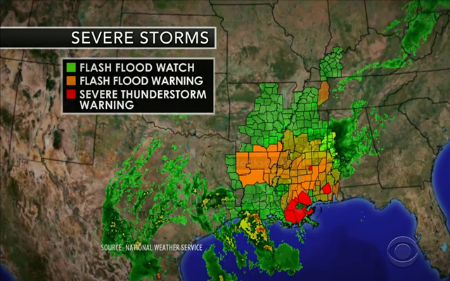
11 March 2016 (The Advocate) – Rivers across Louisiana are breaking flood records as heavy rains slowly inch south, causing flash floods that are threatening businesses, homes and lives throughout the state. From the widespread flooding in north Louisiana that forced the closure of Interstate 20, to the record-breaking levels seen on the Sabine River in western Louisiana to the ongoing flash flooding in large portions of southeast Louisiana, government officials and residents are finding themselves in a struggle against nature. Emergency officials across the state have been responding to people stranded in their homes or struggling on the roadways. The almost 800 Louisiana National Guard personnel engaged in flood evacuations and search and rescue operations brought more than 1,700 residents and 162 pets to safety as of Friday evening, and that doesn’t account for the rescues by local law enforcement. Comparisons to the April 1983 flood are inevitable as water levels approach, or pass, those seen during that benchmark flood, which was caused by a 50-hour downpour across the region. That flood, which also broke river flood records, damaged thousands of homes in Livingston, Ascension and East Baton Rouge parishes. Central residents remember it well, as officials keep an eye on Comite River forecasts of even higher river levels than they saw in 1983, when the river reached 29.72 feet. River forecasts now have the Comite River near Joor Road rising to 30.5 feet early Saturday. “We’re getting prepared for overnight and tomorrow,” Mayor Jr. Shelton said Friday. [more]
Louisiana in struggle vs. nature as rivers flood, break 1983 records; see projected crest times, heights 
By Jeff Masters
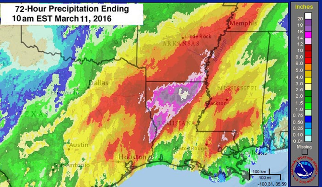
11 March 2016 (wunderground.com) – A state of emergency has been declared by Governor John Bel Edwards for the entire state of Louisiana after a four-day deluge of rain dumped up to 20″ of rain over northern portions of the state. The resulting record flooding has forced a call-up of the National Guard to help evacuate thousands of people from their homes. Five storm-related deaths have been reported since Monday–three in Louisiana and one each in Oklahoma and Texas. Hundreds of roads have been closed, including portions of two major interstate highways. One bridge collapsed on Louisiana Highway 557 in Ouchita Parish. […]Record warmth continues across the Northeast
As if Wednesday’s high of 77°F left any doubt that spring had sprung early in New York City, Thursday doubled up with a high of 79°F. This broke the previous day’s record as the warmest temperature ever notched so early in the year in 145 years of record-keeping at Central Park. Even more impressive was Thursday’s “low” temperature: a ridiculous 63°F! That’s the warmest daily minimum Central Park has seen during any winter–or for that matter, on any date falling between November 10 and March 28–since measurements began in 1871. For maximum shock value, we can employ Thursday’s average temperature of 71°F (calculated by adding the daily high and low and dividing by 2). A reading like this would be most likely to occur in New York during late June or late August. The latest such reading in Central Park annals is 71°F on November 2, 1971; the record-earliest value this warm was 71.5°F on 28 March 1998. [more]
Floods From up to 20 Inches of Rain Create State of Emergency in Louisiana
