Rising seas may swallow albatross nesting grounds sooner than expected – ‘Sea level rise is happening even faster than predicted, which means that these impacts will happen even sooner’
By Hannah Waters
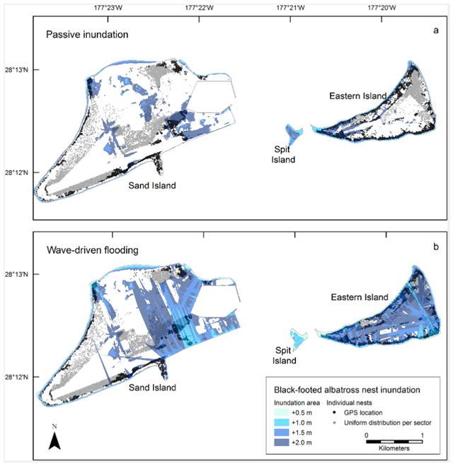
8 October 2015 (Audobon) – The winter of 2011 was a bad one for seabirds nesting at Midway Atoll, a remote spread of islands in the central Pacific. First, two big storms, hit, in January and February, causing large waves to flood the islands. Then in March the islands were washed over by the Tōhoku tsunami (the same wave that caused Japan’s Fukushima Daiichi nuclear disaster). The tsunami wreaked havoc in Midway too: All told, nearly 300,000 albatross nests were destroyed, along with the nests of many other seabird species. “From the storms, there was a lot of nest loss, a lot of eggs that were lost, and young chicks that were lost,” recalls Karen Courtot, a wildlife biologist with the U.S. Geological Survey who monitors Midway’s seabirds. Courtot studies how sea level rise will affect these birds, and for her, that winter’s destruction drove home how flooding from big storms will threaten nesting seabirds even before rising seas swallow their islands. Midway Atoll is one of the biggest seabird colonies in the world. There, 19 seabird species, including 75 percent of the world’s Laysan Albatross population, gather to breed. The islands’ more than 1,500 acres does not mean they are safe—“[the atoll is] actually quite vulnerable to sea level rise,” Courtot says. The islands are low-lying, averaging 3.2 meters in elevation, and sea level at Midway is rising at a rate of 5 millimeters per year—faster than the global average—which makes the impact of storms all the greater. Courtot and her team “wanted to look closer at what species would be most vulnerable,” she says. To do so, they built an extremely detailed computer model of Midway and its birds. First they flew a plane equipped with LIDAR instruments that could collect high-resolution elevation measurements over the island. They combined this data with seafloor maps to create a 3-D model. Then they filled in their model ocean with decades of storm wave data, and drew in thousands of GPS-located nests of three species that nest on Midway’s ground during the winter: Laysan Albatrosses, Black-footed Albatrosses, and Bonin Petrels. Once their model was built, they could see what parts of the islands—and which bird species—would be swept away by the fierce waves of winter storms. The model shows that rising waters alone present little threat to nesting birds in the near future—when sea level increases by 1.5 meters, less than 10 percent of any given nesting habitat will be submerged. But the threat of winter storms hastens the danger. In their model, after 1.5 meters of sea level rise, storm waves washed out 25 percent of Midway Atoll’s land area, taking 40 percent of ground nests (as well as 20 percent of grass nests, and 15 percent of tree nests). And after 2 meters of sea level rise, storms flooded more than half of the land area, washing out 60 percent of the nests—affecting more than 600,000 breeding albatrosses and petrels, which is equal to about one-quarter of their Midway populations. While it’s still unclear exactly when sea level will reach these heights, according to NASA, scientific estimates confirm that we’ve already committed to nearly one meter of rise, at least. All of which adds up to trouble for the birds—and soon. “When you include the storm wave piece on top of the sea level rise piece, the impacts happen a lot earlier,” says Nat Seavy, research director of bird conservation non-profit Point Blue (he was not involved in the research). “And sea level rise is happening even faster than predicted, which means that these impacts will happen even sooner.” [more]
Climate Change May Swallow Albatross’ Nesting Grounds Sooner Than We Thought via Faster Than Expected
ABSTRACT: More than 18 million seabirds nest on 58 Pacific islands protected within vast U.S. Marine National Monuments (1.9 million km2). However, most of these seabird colonies are on low-elevation islands and sea-level rise (SLR) and accompanying high-water perturbations are predicted to escalate with climate change. To understand how SLR may impact protected islands and insular biodiversity, we modeled inundation and wave-driven flooding of a globally important seabird rookery in the subtropical Pacific. We acquired new high-resolution Digital Elevation Models (DEMs) and used the Delft3D wave model and ArcGIS to model wave heights and inundation for a range of SLR scenarios (+0.5, +1.0, +1.5, and +2.0 m) at Midway Atoll. Next, we classified vegetation to delineate habitat exposure to inundation and identified how breeding phenology, colony synchrony, and life history traits affect species-specific sensitivity. We identified 3 of 13 species as highly vulnerable to SLR in the Hawaiian Islands and quantified their atoll-wide distribution (Laysan albatross, Phoebastria immutabilis; black-footed albatross, P. nigripes; and Bonin petrel, Pterodroma hypoleuca). Our models of wave-driven flooding forecast nest losses up to 10% greater than passive inundation models at +1.0 m SLR. At projections of + 2.0 m SLR, approximately 60% of albatross and 44% of Bonin petrel nests were overwashed displacing more than 616,400 breeding albatrosses and petrels. Habitat loss due to passive SLR may decrease the carrying capacity of some islands to support seabird colonies, while sudden high-water events directly reduce survival and reproduction. This is the first study to simulate wave-driven flooding and the combined impacts of SLR, groundwater rise, and storm waves on seabird colonies. Our results highlight the need for early climate change planning and restoration of higher elevation seabird refugia to prevent low-lying protected islands from becoming ecological traps in the face of rising sea levels.
Will the Effects of Sea-Level Rise Create Ecological Traps for Pacific Island Seabirds?
