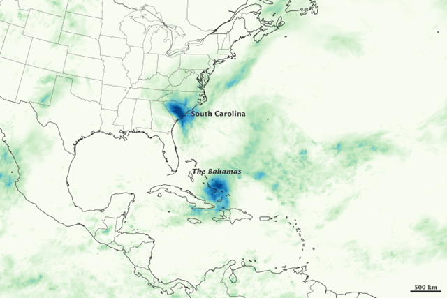
Image of the Day: Satellite view of devastating rainfall in the Bahamas and South Carolina, 1-5 October 2015
By Mike Carlowicz
5 October 2015 (NASA) – A major October hurricane in the Atlantic Ocean never made landfall, yet it has wreaked havoc in the Americas. Hurricane Joaquin sat just offshore of The Bahamas for several days, pounding the island nation with category 4 winds and flooding rain. Meanwhile, in the southeastern United States, a separate, yet Joaquin-influenced weather system brought intense rainfall and both inland and coastal flooding. The map above shows satellite-based estimates of rainfall in the northwestern Atlantic Ocean from October 1–5, 2015, as compiled by NASA. These rainfall totals are regional, remotely-sensed estimates, and local totals reported by ground-based weather stations can be significantly higher or lower. The darkest blues on the map represent rainfall totals approaching 800 millimeters (31.5 inches) over the five days observed. The rainfall data come from the Integrated Multi-Satellite Retrievals for GPM (IMERG), a product of the Global Precipitation Measurement mission. IMERG pulls together precipitation estimates from passive microwave and infrared sensors on several satellites, as well as monthly surface precipitation gauge data, to provide precipitation estimates between 60 degrees North and South latitude. GPM is a partnership between NASA and the Japan Aerospace Exploration Agency. Hurricane Joaquin is one of the strongest hurricanes to ever hit The Bahamas as late as October. Winds surpassed 144 knots (165 miles per hour) on October 3, and the hurricane was nearly stationary off of Long Island for nearly two days. Civil authorities are only beginning to assess the damage, but many low-lying areas were flooded and several islands were without electric power. A cargo ship with 33 crew members disappeared—likely sunk—in the waters off of the islands. To the north and west, much of the eastern United States has been soaked with rainfall for nearly a week, though no state was hit as hard as South Carolina. Fueled by a relentless flow of tropical moisture from warm Atlantic waters and from the fringes of Joaquin, rainfall totals surpassed 600 millimeters (24 inches) in what some local authorities referred to as a “1,000-year event.” According to Weather Underground, three-day rainfall records were set in Columbia and Charleston, South Carolina. U.S. Geological Survey gauges at Black River in Kingstree (South Carolina) recorded 618 millimeters (24.3 inches) from September 29 to October 5, 2015. According to National Weather Service reports, the coastal city of Charleston totaled 423 millimeters (16.6 inches), while the inland city of Columbia measured 296 millimeters (11.7 inches) Click here to see an animation of the IMERG data compiled with each satellite pass over a week.References and Related Reading
- Dr. Jeff Masters’ WunderBlog, via Weather Underground (2015, October 4) Devastating Rains in South Carolina; Joaquin Lashing Bermuda. Accessed October 5, 2015.
- Dr. Jeff Masters’ WunderBlog, via Weather Underground (2015, October 3) Joaquin Close to Category 5 Strength; Rains Inundate Carolinas. Accessed October 5, 2015.
- Dr. Jeff Masters’ WunderBlog, via Weather Underground (2015, October 2) Joaquin Still Gripping Bahamas; #NotJoaquin Dousing Carolinas, Virginia. Accessed October 5, 2015.
- NOAA Advanced Hydrologic Prediction Service (2015) Water: River Conditions. Accessed October 5, 2015.
- U.S. Geological Survey (2015) USGS Current Conditions for South Carolina—Precipitation. Accessed October 5, 2015.
- Washington Post (2015, October 5) The meteorology behind South Carolina’s catastrophic, 1,000-year rainfall event. Accessed October 5, 2015.
- WYFF (2015, October 5) Rain Totals around SC/NC: Thursday–Sunday. Accessed October 5, 2015.
