40 million people depend on the Colorado River, and now it’s drying up – ‘Quite honestly, we are alarmed and concerned about the implications of our findings’
By Tom Philpott
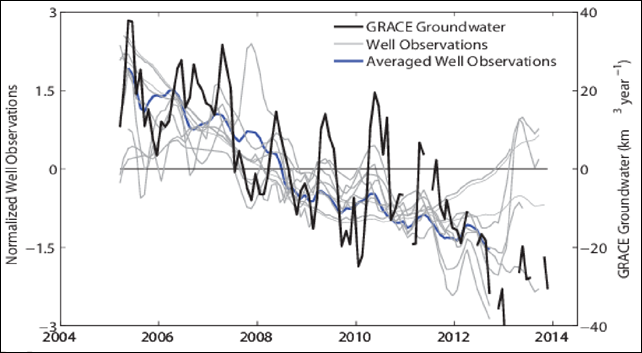
4 August 2014 (Mother Jones) – Science papers don’t generate much in the way of headlines, so you’ll be forgiven if you haven’t heard of one called “Groundwater Depletion During Drought Threatens Future Water Security of the Colorado River Basin,” recently published by University of California-Irvine and NASA researchers. But the “water security of the Colorado River basin” is an important concept, if you are one of the 40 million people who rely on the Colorado River for drinking water, a group that includes residents of Las Vegas, Los Angeles, Phoenix, Tucson, and San Diego. Or if you enjoy eating vegetables like broccoli, cauliflower, and spinach during the winter. Through the many diversions, dams, canals, and reservoirs the river feeds as it snakes its way from the Rockies toward Mexico, the Colorado also provides the irrigation that makes the desert bloom in California’s Imperial Valley and Arizona’s Yuma County—source of more than two-thirds of US winter vegetable production. We’ve known for a while that the river’s ability to meet such demands has become increasingly strained. Climate change means less snowmelt in the Rockies, the river’s source, and a 14-year drought in the Southwest has further impeded its flow, while adding to the demand on it. “The once broad and blue river has in many places dwindled to a murky brown trickle,” the New York Times reported in January. “Reservoirs have shrunk to less than half their capacities, the canyon walls around them ringed with white mineral deposits where water once lapped.” Lake Mead, the vast Nevada reservoir that traps a portion of the Colorado’s annual flow for distribution to its various users, has sunk to its lowest level since its creation in the 1930s, under pressure from the past decade and a half of drought. According to an excellent National Geographic piece by Sandra Postel of the Global Water Policy Project, Lake Mead was hovering near capacity when the drought started in 2000, equivalent to about two full years of Colorado River water. Today, it holds just nine months worth of river flow—a steep drop. But the new paper suggests that the situation is even worse than we previously knew. In addition to rapidly drawing down Lake Mead, the region’s thirst for water has extended underground: to the region’s aquifers. For a project called the Gravity Recovery and Climate Experiment, or GRACE, NASA satellites circle the Earth and carefully measure its mass. “Because changes in water storage result in changes in mass, GRACE provides fairly accurate estimates of water depletion over time,” Postel explains. And here’s what GRACE researchers found in the Colorado River Basin region: To make up for the gap between what the Colorado River supplies and what people and agriculture demand, farmers, landowners, and municipalities are dropping wells and tapping underground aquifers at a much faster rate than had been assumed. Between December 2004 and November 2013, the Colorado Basin surrendered almost 53 million acre-feet of underground water—roughly equal to about 1.5 full Lake Meads, siphoned away in just nine years. “Quite honestly, we are alarmed and concerned about the implications of our findings,” study coauthor Jay Famiglietti, a senior water scientist at NASA and a professor of at the University of California-Irvine, wrote in a blog post. [more]
40 Million People Depend on the Colorado River. Now It’s Drying Up.
ABSTRACT: Streamflow of the Colorado River Basin is the most over-allocated in the world. Recent assessment indicates that demand for this renewable resource will soon outstrip supply, suggesting that limited groundwater reserves will play an increasingly important role in meeting future water needs. Here we analyze nine years (December 2004 to November 2013) of observations from NASA’s GRACE mission and find that during this period of sustained drought, groundwater accounted for 50.1 km3 of the total 64.8 km3 of freshwater loss. The rapid rate of depletion of groundwater storage (−5.6 ± 0.4 km3 yr−1) far exceeded the rate of depletion of Lakes Powell and Mead. Results indicate that groundwater may comprise a far greater fraction of Basin water use than previously recognized, in particular during drought, and that its disappearance may threaten the long-term ability to meet future allocations to the seven Basin states.
Groundwater Depletion During Drought Threatens Future Water Security of the Colorado River Basin
