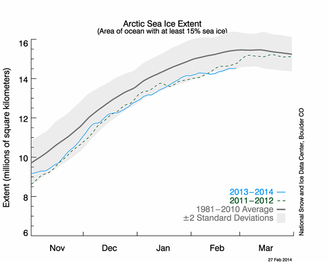
Graph of the Day: Arctic sea ice at record low for February
By Brian Kahn
19 February 2014 (Climate Central) – Arctic sea ice growth has slowed dramatically in recent weeks, thanks in large part to abnormally warm air and water temperatures. Sea ice now sits at record low levels for mid-February. According to the National Snow and Ice Data Center, as of February 18, sea ice covered about 14.36 million square kilometers in the Arctic. The previous low on this date was 14.37 million square kilometers in 2006. The main culprit — in addition to the overall trend of global warming — is likely the rash of warm temperatures. With the polar vortex bringing cold air down to the U.S. this winter, warmer temperatures have been the norm in the Arctic. From February 1-17, temperatures were 7.2° to 14.4°F above normal for much of the Arctic. Some areas have been even warmer. “Right now, the Arctic is pretty warm everywhere. If I look at temperature anomalies, there’s a huge anomaly over the Barents Sea and Sea of Okhotsk of about 10°C (above normal) compared to 1981-2010,” said Julienne Stroeve, a senior scientist at the National Snow and Ice Data Center. Stroeve also said that warm waters in the North Atlantic have slowed ice growth, which is part of a decades-long trend due to both natural variability and human influences. The decline in sea ice is one of the key indicators of climate change. Sea ice in January, the last full month for which data is available, has declined 3.2 percent per decade since 1979 compared to the 1981-2012 average. That equals roughly 18,500 square miles in ice lost per decade, the same area as Vermont and New Hampshire combined. This past January ranked as the fourth-lowest year on record, with 2011 being the all-time record lowest. [more]
