Typhoon Phailin bearing down on India with winds and rain – ‘It’s going to cause pretty complete devastation on the coast where it hits’
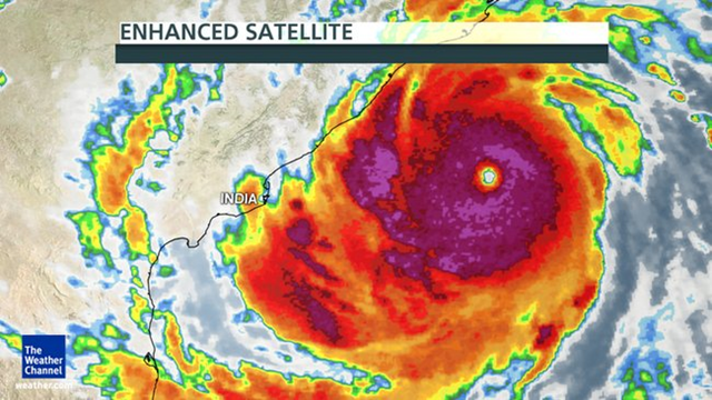
KENDRAPARA, India, 11 October 2013 (UPI) – Rough seas forced fishing vessels to return to port Friday as Typhoon Phailin bore down on India’s Bay of Bengal, officials said. Four fishermen were rescued a day after their ship capsized near the Gahirmatha and Bhitarkanika marine sanctuaries, Paradip marine fisheries officer Ranjit Keshari Dash told Press Trust of India. The fishermen had put to sea despite the typhoon warnings but Dash had no reports of any fishing vessels stranded at sea. With the potential to intensify into a super storm, Phailin was expected to make landfall Saturday evening at Gopalpur in Odisha state. More than 260,000 people were being evacuated from low-lying areas. The Joint Typhoon Warning Center Friday classified the storm as a Category 4 and said it could increase in intensity to a Category 5 by Saturday. Some forecasters compared the size and intensity of the typhoon to Hurricane Katrina, which hit the U.S. Gulf Coast and New Orleans in 2005, the Hindustan Times said. The storm was 254 miles southeast of Kalingapatnam in Andhra Pradesh and winds of 28 to 34 mph were already recorded off the Odisha coast, said the India Meteorological Department. “It will increase in intensity with gale wind speed reaching 130 to 136 mph along and off coastal districts of south Odisha at the time of landfall.” This portion of the coast is particularly susceptible to storm surge flooding, The Weather Channel said. The India Meteorological Department predicted heavy rains and storm surges of nearly 5 to 8 feet above astronomical tide, The Times of India said. Such surges would inundate the areas of Ganjam, Khurda, Puri, and Jagatsinghpur in Odisha state.
India: Typhoon Phailin bearing down on India with winds and rain 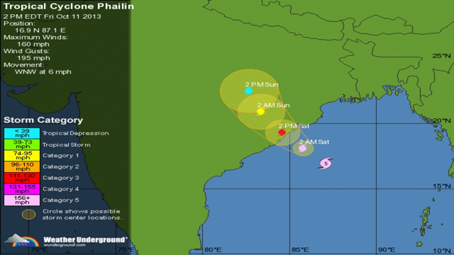
By Brian K. Sullivan and Bibhudatta Pradhan
11 October 2013 (Bloomberg) – Cyclone Phailin, the most powerful storm to take aim at India’s East Coast since 1999, forced the evacuation of thousands along the Bay of Bengal as it threatened to flood escape routes, disrupt rail services and cut off power for weeks. Phailin, which means “sapphire” in Thai, has winds of 220 kilometers (135 miles) per hour and was expected to go ashore at about 6 p.m. local time, according to L.S. Rathore, director-general of the India Meteorological Department. The U.S. Navy’s Joint Typhoon Warning Center in Hawaii estimated Phailin’s top winds at a Category 5-level 259 kph on the American hurricane scale, which is different than the one used by the rest of the world. Hurricane Andrew in 1992 was a Category 5 storm. “The storm has the potential to cause huge damage,” Rathore said. “We don’t contemplate it will further intensify. It will remain as a very severe cyclonic storm.” Phailin sent at least 64,000 people fleeing from their homes and forced ships out of its path, and is expected to cause crop and infrastructure damage. Twenty-six of the world’s 35 deadliest tropical cyclones, the storms that include hurricanes and typhoons, have occurred in the Bay of Bengal, according to Jeff Masters, founder of Weather Underground in Ann Arbor, Michigan. “It’s going to cause pretty complete devastation on the coast where it hits,” Masters said by telephone. The storm weakened slightly as it grew larger but had begun to strengthen. Masters said it was likely Phailin would lose some strength before going ashore, probably in the Odisha region, as the equivalent of a Category 4 storm, the second-strongest on the five-step Saffir-Simpson Scale. Andrew, which hit southern Florida, had top winds of 280 kph and was a 240-kph storm when it made landfall, according to AccuWeather Inc. in State College, Pennsylvania. Paradip Port Trust, India’s biggest dry bulk cargo facility, moved all its ships to sea and shut down operations, spokesman Prakash Chandra Mishra said by phone. The National Disaster Management Authority dispatched a 1,500-strong rescue force to Odisha and Andhra Pradesh states, while the Indian Air Force said it sent two IL-76 airlift teams and was committing two C-130J Super Hercules planes. Andhra Pradesh’s Chief Minister, Kiran Kumar Reddy, urged citizens in low-lying areas to move to safer ground. There will probably be “large scale” disruptions to power and communication lines and rail and road traffic as well as extensive damage to crops, he said in a statement. […] Phailin is the strongest since a cyclone with maximum wind speeds of 260 kph lashed Odisha in 1999, killing about 9,000 people, damaging 2 million houses and destroying crops spread over 1.65 million hectares. Masters said the topography of the land makes storm impact worse because it is so flat. The 1999 cyclone, which struck about 100 miles north of where Phailin is expected to come ashore, came about two weeks after another major storm hit the area, exacerbating flooding, Masters said. Changes in infrastructure, weather forecasting and emergency services will probably mean the death toll from Phailin won’t be as high as it was 14 years ago, he said. [more]
Cyclone Phailin Forces Thousands to Flee Eastern India 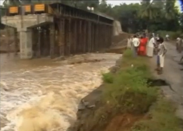
11 October 2013 (Sky News) – More than 250,000 villagers have fled their homes as a huge cyclone gathers strength and heads towards India’s east coast. Cyclone Phailin – which is already so large it has nearly filled the Bay of Bengal – is expected to be the fiercest storm to hit India since a devastating cyclone killed 10,000 people 14 years ago. Large waves are already pounding beaches in the state of Andhra Pradesh a day before the storm is due to hit. Villagers along the coast were evacuated to schools in the north of the state and in neighbouring Odisha, while panic buying drove up food prices. Satellite images showed Phailin some 310 miles (500km) off the coast and likely to make landfall on Saturday night (3pm-6pm UK time), with widespread flooding expected. Some forecasters likened its size and intensity to hurricane Katrina, which devastated the US Gulf coast and New Orleans in 2005. Many villagers said they had not been told to evacuate, and others were refusing to leave their homes. “Of course I’m scared, but where will I move with my family?” said Kuramayya, 38, a fisherman from the village of Bandharuvanipeta, while 12ft waves crashed behind him. “We can’t leave our boats behind.” The Indian Meteorological Department said Phailin would hit between Kalingapatnam in Andhra Pradesh and the port of Paradip in Odisha state and predicted storm surges 10ft above normal tides. It described it as a “very severe cyclonic storm” with winds of 130-135 mph but resisted upgrading it to a stronger “super cyclone”. However, London-based storm tracking experts Tropical Storm Risk said Phailin was a super cyclone and placed it in the most powerful Category 5 of storms. That was the same strength of storm that battered Odisha in 1999, killing thousands. “Phailin will be no less than the 1999 super cyclone,” said Odisha state’s Special Relief Commissioner Pradeep Kumar Mohapatra. [more]
Cyclone Phailin: Thousands Flee In East India