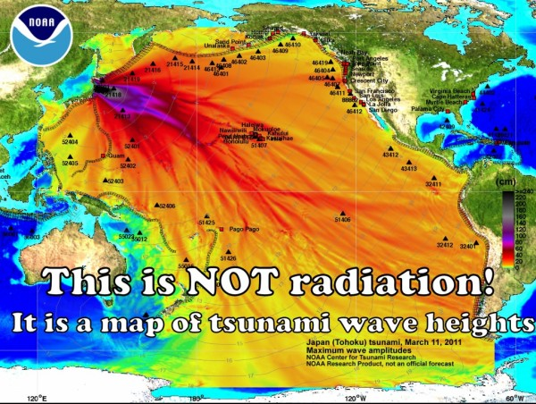
Fukushima meltdowns have not polluted the entire Pacific Ocean, no need to panic!
By Candace Calloway Whiting
28 August 2013 (Seattle PI) – From NOAA:This image was created by NOAA’s Center for Tsunami Research and graphically shows maximum wave heights (in centimeters or cm) of the tsunami generated by the Japan earthquake on March 11, 2011. It does NOT represent levels of radiation from the damaged Fukushima nuclear power plant. For more information please visit the original image and background information at http://nctr.pmel.noaa.gov/honshu20110311.
This map of wave heights is circulating all over the internet along with panic and a sprinkling of facts (I added the text over this map, hoping that this version will help combat the fear mongering). But the reality is, even if there were radiation of this magnitude crossing the ocean, the map wouldn’t look anything like that – the ocean circulation is way more complex with masses of water spinning, sinking, stalled, or streaming like a river. Sometimes the ocean mixes up, and sometimes it doesn’t, with layers sitting on top of each other. Fresh water from rivers can go way out to sea, and wedges of salt water can travel up river. […] Does that mean we are all safe and can continue to live as though it is safe to eat anything in the ocean? Absolutely not, we have been dumping radiation into the environment for decades. Many species of fish travel this circle of ocean currents too, and will pick up increasing contamination with every swim by Japan. Little creatures that live in the ocean bottom near the reactor will stir up the sand and mud, and release some of the particles that are the worst, releasing those radioactive particles into the water and absorbing them at ever-increasing rates. Big fish eat little fish, and the problem escalates right up the food chain. And for anyone who thinks it is a good idea to eat marine mammals of any kind, guess again – as top-level predators they will get the worst doses. [more]
Fukushima Meltdown Has Not Polluted the Entire Pacific, No Need to Panic!

More red herring deflections of what is really going on.
There is a REAL map / video representation on the spread of contamination in the Pacific Ocean.
You can find this here:
http://www.youtube.com/watch?v=HStCM2l83Cc
Science source is here:
http://oceanrep.geomar.de/14788/
The Pacific is being widely contaminated. Many credible sites and sources are now documenting this very clearly.
~Survival Acres~
This disinfo prompted me to blog:
Major Disinformation Being Released on Fukushima
Radioactive contamination is the worst of all types, since it will last for a long time. Unfortunately, earth, water and air is contaminated by some 3000 nuclear and thermonuclear bombs tested since 1945. I used to live in Laguna Beach, Southern California. Every morning, I used to go to the sea and dive to collect few sea urchins and abalones to feast on them at noon. After all orange groves in Orange County were replaced by rows and rows of houses, I moved out to another place. Few year later, after San Clemente (15 miles south of Laguna Beach) nuclear plant started, I visited friends in Laguna Beach. As before, I dived for some sea urchins… and was very surprised to find ocean floor dead. Were there used to be life, there was nothing more but rocks and sand. Even kelp was gone.
After, I decided to move out of North America. Clean water, air and sunlight are more important than anything else. Nothing can replace a good health!
I was in Kona Hawaii when the Tsunami's hit…
They were over 9 ft high and you can see them on youtube under Kona Tsunami.
I watched the man film this.
That map is the extent of cesium contamination.
Cm doesn't mean centimeters and that wasn't wave heigth…
40 centimeters makes 14 inches… go look at those films and tell me that was 14 inches….
Do some research.