Sumatra haze fires concentrated in deforested peatlands, not forest areas, satellite analysis confirms – Palm oil and pulp and paper companies are responsible
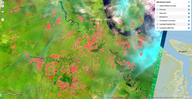
10 July 2013 (mongabay.com) – A new mapping tool based on NASA satellite data confirms that the majority of fires that drove the recent haze over Sumatra and Malaysia were concentrated in deforested peatlands and scrub, rather than natural forest areas. The interactive fire risk tool, developed by the Center for International Forestry Research (CIFOR), maps fire scars using high-resolution satellite imagery from NASA’s new Landsat 8 satellite. It also provides before and after pictures of areas affected by fires in Riau, where the bulk of hotspots were detected last month. CIFOR says that unlike the major fires in the region in 1982-1983, 1997-1998 and 2006, few fires were located in natural forest areas. “The fires are burning in plantation forests where they may have been set purposely in rotation as a method of boosting crop production on oil palm plantations and timber plantations – a practice known as swidden – or slash-and-burn agriculture,” writes CIFOR’s Julie Mollins in a blog post. David Gaveau, a scientist at CIFOR, adds that the tool could help with investigation into the origin of the fires. “A web-based application such as this one is useful because government officials and civil society can check the location, shape and size of the fire scars, whether the fires occurred in moratorium areas, concessions or in vegetation cover before-and-after-fire – crucial information for field investigations,” he said The findings are consistent with reports from the World Resources Institute (WRI) and Eyes on the Forest, a Sumatra-based coalition of environmental groups. WRI data indicates that roughly half of hotspots recorded during the peak of the haze crisis were located in concessions belonging to palm oil and pulp and paper companies. [more]
Haze fires concentrated in deforested peatlands, not forest areas, confirms satellite analysis