Scientists watch Arctic cyclone chew up sea ice
By Scott Sutherland
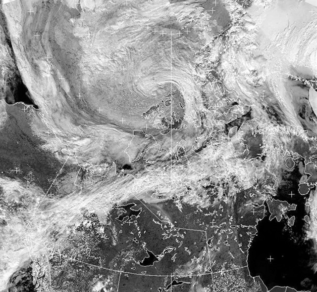
26 July 2013 (Geekquinox) – Scientists’ eyes have been glued to the Arctic this past week, as a summer cyclone has been tearing through the sea ice at the north pole. Ice melting at the North Pole during the summer months isn’t exactly a rare occurrence, but what’s remarkable is the speed and extend of the recent loss, and what this could mean for the trend that scientists have been seeing in the past decade. Sea ice in the Arctic goes through a cycle, usually reaching its maximum extent sometime in March and reaching its minimum extent sometime in September. Over the past few decades, scientists have been observing an alarming trend, where the extent of the ice in the Arctic, both the maximum and the minimum, is getting smaller. Last year was particularly disturbing, as it reached a minimum extent in September of 3.413 million square kilometres, which set a record low that blew away any other year we’ve seen so far. […] “We have a whole new class of sea ice in the Arctic, which we’re calling ‘decayed ice,”‘ said David Barber, an Arctic scientist at the University of Manitoba, who is one of Canada’s top experts on sea ice, according to CTV News. “We started seeing it in 2009. It’s extremely weak.” […] “The effects of [this storm] are nowhere near what we saw last August,” said Matthew Asplin, a sea-ice climatologist with the University of Manitoba, according to CTV News. “But because the ice is thinner and it’s already been pre-conditioned, and because there’s less volume, it’s much more vulnerable to impacts from this sort of thing.” [more]
Scientists watch Arctic cyclone churn through northern sea ice
By Bob Weber
25 July 2013 (The Canadian Press) – Arctic scientists are watching in awe this week as a raging summer cyclone tears up what could become a record amount of rotting northern sea ice. “We’re really watching this year with a lot of fascination,” said Matthew Asplin, an Arctic climatologist at the University of Manitoba. Arctic cyclones are driven by low-pressure systems in which winds of up to 100 km/h blow counter-clockwise in spiral more than 1,000 kilometres across. They occur in both winter and summer, but are usually stronger in winter. Cyclones are not unusual in the Arctic, but seem to be changing in recent years, said David Barber, one of Canada’s top sea-ice experts. “These cyclones are not getting more frequent, but they are getting deeper — which means stronger,” he said. And they’re getting harder on sea ice, which they break up through wave action associated with high winds and through rainfall, which darkens the ice and makes it absorb more solar energy. The storms also bring up water from the depths, which is actually warmer than surface water. Cyclones can destroy large amounts of ice very quickly. “In 2009, we actually documented one of these events in which large, multi-year ice floes — Manhattan-sized — broke up in a matter of minutes,” said Barber. Last year, a particularly powerful cyclone is thought to have wiped out 800,000 square kilometres of ice. That contributed to record low sea-ice levels at the end of the 2012 melt year. This year’s storm over the Beaufort Sea formed about mid-week and is expected to die out on the weekend. It isn’t as strong as last year’s, but the ice is thinner and weaker. As well, the ice has already been pummelled by earlier storms. [more]
Scientists watch Arctic cyclone chew up sea ice
Thank you for posting this. You consistently post news that no one else does. It's a pleasure to follow your blogs.
I agree with DiAnne. You post great stuff that no else does. I read this blog daily. Thanks for the effort and thanks for sharing.
Have a nice day sir.