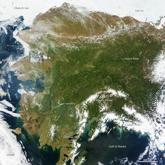
Why NASA’s latest photo of Alaska is freaking people out
By JAKE ELLISON
21 June 2013 (Seattle PI) – At first glance, it’s just a great photo of nearly the entire state of Alaska on an exceptionally clear day. What could be the problem? Well, turns out that photo shows an anomaly that some are fretting signifies yet another big shift in global climate – a shift toward the hot. NASA writes (without saying “global warming”): “The same ridge of high pressure that cleared Alaska’s skies also brought stifling temperatures to many areas accustomed to chilly June days. Talkeetna, a town about 100 miles north of Anchorage, saw temperatures reach 96°F on June 17. Other towns in southern Alaska set all-time record highs, including Cordova, Valez, and Seward. The high temperatures also helped fuel wildfires and hastened the breakup of sea ice in the Chukchi Sea.” Oh, crap. A writer for Slate rings the alarm bell the loudest:The melt in Greenland and the high temperatures in Alaska may be more signs—like we needed more—of the reality of climate change. Even scarier is the fact that the climate models used before didn’t predict this sort of thing. The climate is very complex, and it’s hard to model it accurately. This is well-known and is why it’s so hard to make long-term predictions. But before the deniers crow that climatologists don’t know what they’re doing, note this well: The predictions made using these models almost always seem to underestimate the effects of climate change. That’s true in this case, too. So it’s not that the models are wrong and therefore climate change doesn’t exist. It’s that the models aren’t perfect, and it’s looking like things are worse than we thought.
Last year, the United State experienced its warmest year ever. And, globally 2012 was the 9th warmest year since 1850 with the years from 2001 to 2012 being among the top 13 warmest on record. The hottest year was 2010, when the average temperature was 58.2 degrees F Now a study released Monday from the United Kingdom provides more fodder for freaking out over that picture of Alaska. In a press release from the University of Sheffield, whose scientist led the research, jet stream changes were blamed for the big ice melt in Greenland … and may signal another big year of heat and melting. (Note: “GrIS” = Greenland ice sheet) [more]
Why NASA’s latest photo of Alaska is freaking people out
By Adam Voiland
19 June 2013 (NASA) – On most days, relentless rivers of clouds wash over Alaska, obscuring most of the state’s 6,640 miles (10,690 kilometers) of coastline and 586,000 square miles (1,518,000 square kilometers) of land. The south coast of Alaska even has the dubious distinction of being the cloudiest region of the United States, with some locations averaging more than 340 cloudy days per year. That was certainly not the case on June 17, 2013, the date that the Moderate Resolution Imaging Spectroradiometer (MODIS) on NASA’s Terra satellite acquired this rare, nearly cloud-free view of the state. The absence of clouds exposed a striking tapestry of water, ice, land, forests, and even wildfires. Snow-covered mountains such as the Alaska Range and Chugach Mountains were visible in southern Alaska, while the arc of mountains that make up the Brooks Range dominated the northern part of the state. The Yukon River—the longest in Alaska and the third longest in the United States—wound its way through the green boreal forests that inhabit the interior of the state. Plumes of sediment and glacial dust poured into the Gulf of Alaska from the Copper River. And Iliamna Lake, the largest in Alaska, was ice free. The same ridge of high pressure that cleared Alaska’s skies also brought stifling temperatures to many areas accustomed to chilly June days. Talkeetna, a town about 100 miles north of Anchorage, saw temperatures reach 96°F (36°C) on June 17. Other towns in southern Alaska set all-time record highs, including Cordova, Valez, and Seward. The high temperatures also helped fuel wildfires and hastened the breakup of sea ice in the Chukchi Sea.

It s all interconnected , the floods in India who killed still uncountably many people, devastated their houses farms , broke more than 20 bridges….
And what about Europe where the rhein and Donau rose more than 8 m than their normal height. The question is not the climatechange, the question is how we will live with it………trying to keep our own butts out of water and keep with our usual lifestyle or really implementing changes that can be devastating for most/all of us.
Get out of the northern hemisphere.
The Ozone hole is closing.
Acid rain was defeated.
We got this; when people are ready.
How long will we actually have — when they finally tell us we are all going to die due to catastrophic climate change? Maybe a year? A month? A week?
Arctic Ocean ice is vanishing — not just slightly reducing, but vanishing.
I cannot help wondering how much time we will have left when they finally, at last, tell us that we are all going to die due to catastrophic climate change. A year? A month? A week? An hour?
Learn to swim … see you down in Arizona bay … J.K.Maynard