Arctic heat wave hits central Siberia, pushing temperatures to 90 degrees F (32C) and sparking tundra fires
[Desdemona wonders if the summer sun in Seattle will again be dimmed by smoke from Siberia megafires, as in 2012.] By Robert Scribbler
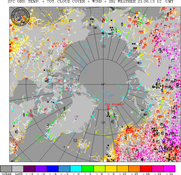
21 June 2013 Today, a heatwave circling the Arctic set its sights on central Siberia. Temperatures soared into the upper 80s to near 90 degrees over a vast region of Siberian tundra, setting off pop-corn thunderstorms and sparking large, ominous fires reminiscent of the blazes that roared through this region during late June of 2012. Those fires were so large they sent a plume of smoke over the Pacific Ocean and blanketed valleys in western Canada. Each individual fire in the above image hosts a plume of smoke about a hundred miles long. The fire to the far left, hosts a very long smoke plume of at least 350 miles in length. You can see these soaring Siberian temperatures and related fires on the Arctic weather map above. Note the instances of 32 degrees Celsius temperatures (which is 89.6 degrees on the Fahrenheit scale). If you look to the right side of the above map, you’ll see a large swath of pink spanning the Arctic from Norway all the way to the Pacific coastal region of Siberia. The most intense heat is located directly in the center of this zone where sporadic readings of 90 degree temperatures start to pop up. Fires are also shown on this weather map, indicated by a vertical black bar with a squiggly black line at the top. Heatwave conditions also appear to have re-flared in Scandinavia where numerous instances of 80 degree + weather appear. Alaska is in its ‘cool night-time’ phase. But even now, some locations in the interior are showing ‘lows’ of 70 degrees — which is hotter than usual highs for this time of year in that region. [more]