Graph of the Day: All-time daily rainfall records on Australia east coast, January 2013
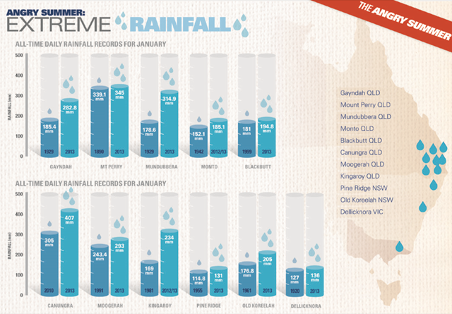
(Climate Commission) – Between 22 and 29 January 2013 extreme rainfall occurred over the east coast of Queensland and the New South Wales coast north of the Illawarra, resulting in severe flooding (BoM, 2013b). Many areas received daily rainfalls greater than 400 mm, with many breaking daily rainfall records (BoM, 2013b) (see Figure 2, Figure 9 and Figure 11). The most impressive record was the one-day rainfall averaged over the Burnett catchment, which was nearly 70% higher than the previous record. The Brisbane river catchment amounts were similar to those observed during the 2011 floods (BoM, 2013b). This heavy rainfall resulted in severe flooding in many areas along the coast of Queensland and far north New South Wales, although the dry lead-up period led to lesser flooding in some areas compared to the 2011 floods (BoM, 2013b). The extreme rainfall triggered severe flooding in many areas within 200 km of the Queensland and far northern New South Wales coastlines (BoM, 2013b; Figure 12). Areas most affected were the Burnett catchment near Bundaberg in Queensland, and the Clarence catchment near Grafton in New South Wales (BoM, 2013b). Both of these rivers reached record flood peaks (BoM, 2013b). Most other rivers peaked below their highest levels of 2010–11 (BoM, 2013b).