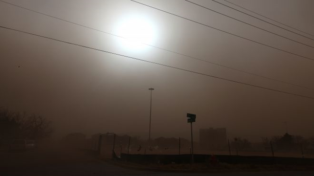
Storms on U.S. Plains stir memories of the Dust Bowl
By Kevin Murphy, with additional reporting by Greg McCune and Christine Stebbins; Editing by Claudia Parsons
31 December 2012 LIBERAL, Kansas (Reuters) – Real estate agent Mark Faulkner recalls a day in early November when he was putting up a sign near Ulysses, Kansas, in 60-miles-per-hour winds that blew up blinding dust clouds. “There were places you could not see, it was blowing so hard,” Faulkner said. Residents of the Great Plains over the last year or so have experienced storms reminiscent of the 1930s Dust Bowl. Experts say the new storms have been brought on by a combination of historic drought, a dwindling Ogallala Aquifer underground water supply, climate change and government farm programs. Nearly 62 percent of the United States was gripped by drought, as of December 25, and “exceptional” drought enveloped parts of Kansas, Colorado, Oklahoma, Texas, and New Mexico, according to the U.S. Drought Monitor. There is no relief in sight for the Great Plains at least through the winter, according to Drought Monitor forecasts, which could portend more dust clouds. A wave of dust storms during the 1930s crippled agriculture over a vast area of the Great Plains and led to an exodus of people, many to California, dramatized in John Steinbeck’s novel, The Grapes of Wrath. While few people believe it could get that bad again, the new storms have some experts worried that similar conditions – if not the catastrophic environmental disaster of the 1930s – are returning to parts of Texas, Oklahoma, New Mexico, Kansas, and Colorado. “I hope we don’t talk ourselves into complacency with easy assumptions that a Dust Bowl could never happen again,” said Craig Cox, agriculture director for the Environmental Working Group, a national conservation group that supports converting more tilled soil to grassland. “Instead, we should do what it takes to make sure it doesn’t happen again.” Satellite images on 19 December 2012 showed a dust storm stretching over an area of 150 miles (240 km) from extreme southwestern Oklahoma across the Panhandle of Texas around Lubbock to extreme eastern New Mexico, said Jody James, National Weather Service meteorologist in Lubbock. Visibility was reduced to half a mile in places, stoked by high winds, he said. At least one person was killed and more than a dozen injured in car crashes. “I definitely think these dust storms will become more common until we get more measurable precipitation,” James said. […] The Ogallala aquifer is drying up after years of drawing out more water than was replenished. Many farmers have had to drill deeper wells to find water. Others are giving up on irrigation altogether, which means they can no longer grow crops of high-yielding and lucrative corn. They will instead grow wheat, cotton, or grain sorghum on dry land, which depends completely on natural precipitation in an area that typically gets 20 inches of rain a year or less. Near Sublette, Kansas, farmer Gail Wright said he would probably give up irrigating two square miles of his land and would plant wheat and grain sorghum instead of corn because of the diminishing aquifer. Drilling deeper wells would cost $120,000 each, Wright said. “When we drilled those wells in the 1960s and 70s, we were doing 1,500 or 1,600 gallons per minute,” said Wright. “Now, they are down to anywhere from 400 to 600 gallons per minute. We probably pumped out 200 feet of water.” Another farmer in Sublette, 79-year-old Lawrence Withers, whose family farms land his grandfather settled in 1887, is resigned to a future without irrigation. “We have pumped 170 feet off the aquifer, that’s gone. There’s just a little tick of water at the bottom,” he said. The Ogallala supplies water to 176,000 square miles (456,000 square km) of land in parts of eight states from the Texas panhandle to southern South Dakota. That amounts to about 27 percent of all irrigated land in the nation, according to the U.S. Geological Survey. The volume of water in the aquifer stood at about 2.9 billion acre feet in 2009, a decline of about 9 percent since 1950, according to the Geological Survey. About two-and-a-half times as much water was drawn out in the 14 years ended 2009 as during the prior 15-year period, data shows. The water may run out in 25 years or less in parts of Texas, Oklahoma, and southwest Kansas, although in other areas it has 50 to 200 years left, according to the Geological Survey. Rationing has been imposed on irrigation in the region but it may be too little too late. “It’s a situation where across the Plains the demand far exceeds the annual recharge,” said Mark Rude, executive director of the Southwest Kansas Groundwater Management District. The worst drought in decades has exacerbated the situation. The semi-arid area around Lubbock, which typically gets about 19 inches of rain a year, received less than 6 inches in 2011, the lowest ever recorded. This year was better but still far below normal at 12.5 inches, meteorologist James said. Climate change is also having an impact on the region, said atmospheric scientist Katharine Hayhoe, co-director of the Climate Science Center at Texas Tech University in Lubbock. “It is definitely hotter in the summer and drier in the summer because of climate change,” she said. The average annual temperature in Lubbock has increased by one full degree over the last decade, according to National Weather Service data, and the average amount of rainfall has fallen during summer months by about .50 inch over the decade. [more]
Storms on U.S. Plains stir memories of the “Dust Bowl”
