Image of the Day: Satellite view of bushfire scars in Australia, 14-15 January 2013

By Adam Voiland
15 January 2013
The Yarrabin fire broke out in the Kybeyan Range on January 6, 2013, burning about 30 kilometers (19 miles) north of Nimmatabel. By January 15, firefighters had contained the blaze, but it had charred more than 10,500 hectares (25,900 acres) of land near Wadbilliga National Forest. The Advanced Land Imager (ALI) on the Earth Observing-1 (EO-1) satellite acquired this image of the affected area on January 15, 2013. Burned vegetation appears red in the false-color image; unburned areas are dark green. Grassland and agricultural land is light green and tan. The fire was one of many that burned across Australia when a record-breaking heat wave struck the country in January. The heat wave, like all extreme weather events, had its direct cause in a complex set of atmospheric conditions that produce short-term weather. However, weather occurs within the broader context of the climate, and there’s a high level of agreement among scientists that global warming has made it more likely that heat waves of this magnitude will occur.
Burn Scar from the Yarrabin Fire in New South Wales 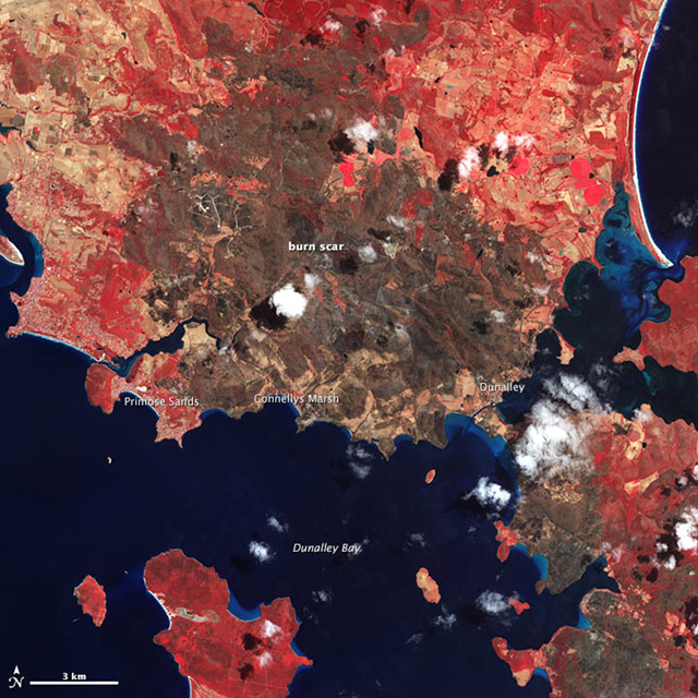
By Adam Voiland
14 January 2013 In January 2013, intense bushfires blazed in Tasmania, an island south of Australia. One of the hardest hit towns was Dunalley, a fishing village on the eastern coast. A blaze destroyed at least 80 homes—about 30 percent of the town— when it tore through the area on January 4, 2013. In the nearby village of Connellys Marsh, 40 percent of the buildings were destroyed. Primrose Sands lost several homes as well. The Advanced Spaceborne Thermal Emission and Reflection Radiometer (ASTER) on NASA’s Terra satellite captured this image of the charred landscape on January 14. Vegetation-covered land is red in the false-color image, which includes both visible and infrared light. Patches of unburned forest are bright red, in contrast with areas where flecks of light brown indicate some burning. The darkest brown areas are the most severely burned. Buildings, roads, and other developed areas appear light gray. Clouds are white. Extreme heat and strong winds fueled the fires. Temperatures in Hobart, the capital of Tasmania, soared to a record high of 41.8 degrees Celsius (107.2 degrees Fahrenheit) on January 4. The heat wave, like all extreme weather events, had its direct cause in a complex set of atmospheric conditions that produce short-term weather. However, weather occurs within the broader context of the climate, and there’s a high level of agreement among scientists that global warming has made it more likely that heat waves and wildfires of this magnitude will occur.