Environmental threat map highlights Great Lakes restoration challenges – ‘The Great Lakes continue to be degraded by numerous environmental stressors’
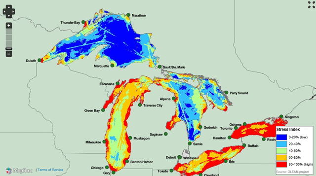
Ann Arbor, Michigan, 20 December 2012 (SPX) – A comprehensive map three years in the making is telling the story of humans’ impact on the Great Lakes, identifying how “environmental stressors” stretching from Minnesota to Ontario are shaping the future of an ecosystem that contains 20 percent of the world’s fresh water. In an article to be published in the Proceedings of the National Academy of Sciences, a group led by researchers at the University of Michigan reports on an expansive and detailed effort to map and cross-compare environmental stresses and the ecological services provided by the five lakes. Their efforts have produced the most comprehensive map to date of Great Lakes’ stressors, and also the first map to explicitly account for all major types of stressors on the lakes in a quantitative way. “Despite clear societal dependence on the Great Lakes, their condition continues to be degraded by numerous environmental stressors,” said David Allan, the project’s lead researcher and a professor of aquatic sciences at the University of Michigan’s School of Natural Resources and Environment. The map gives federal and regional officials an unprecedented scientific foundation upon which to sustainably manage the Great Lakes, the researchers conclude. The environmental stress map was developed by a bi-national team of researchers from academia and environmental organizations known as the Great Lakes Environmental Assessment and Mapping (GLEAM) project. The team drew upon the latest and best data from federal and state agencies as well as non-governmental organizations and individual researchers. The map represents the combined influence of nearly three dozen individual stressors and is incredibly detailed for a region spanning nearly 900 miles, showing impacts at the scale of half a mile. Thirty-four stressors were examined, including coastal development, pollutants transported by rivers from agricultural and urban land, fishing pressure, climate change, invasive species and toxic chemicals (the full list is at www.greatlakesmapping.org). […] “Basically, our work itemizes the laundry list of things that need to be fixed and where they occur,” said co-author Peter McIntyre, who began work on the study as a postdoctoral fellow at the University of Michigan and is now a professor at the University of Wisconsin-Madison’s Center for Limnology. “This information can be used in any given location by local officials and citizen groups.” [more]
Environmental threat map highlights Great Lakes restoration challenges