Australia rainfall records tumble as storm heads south – Winds whip up bushfires in Victoria

By Peter Hannam, Carbon economy editor
29 January 2013 (Sydney Morning Herald) – Update A slew of January rainfall records were broken as the remnants of ex-tropical cyclone Oswald heads south along the NSW coast. Pine Ridge, south of Tamworth, copped 131 millimetres of rain in the 24 hours to 9am Tuesday, setting an annual record, according to Aaron Coutts-Smith, NSW manager of climate services at the weather bureau. Other notable falls include Wyee, near Lake Macquarie, which received 171.8mm, its highest tally for January in 113 years of records. Grafton’s Olympic site notched its highest January rainfall of 131mm in the 24 hours to 9am on Monday. Also setting a new high for any month was Old Koreelah, inland from Byron Bay, which collected 205mm in its rain gauge in the 24 hours to 9am Monday – the most in a century of records. Initial numbers point to Crystal Creek on the mid-north coast’s Bellinger River as recording the highest rainfall total of 288 millimetres in the 24 hours to 9am Tuesday, as the storm system tracked south. Sydney’s Observatory Hill recorded 95 millimetres of rain for the period, the highest level since last March’s severe rainstorms. In the Sydney region, the north shore’s French’s Forest and Castle Cove both saw 161 millimetres land in their rain gauges. The Upper Rous River saw the state’s heaviest falls from the storm, with 944 millimetres landing in the border zone site near Queensland in the past three days. “It’s not far short of a metre of rain,” said Dr Coutts-Smith. “When you think of those volumes, it’s no wonder there has been flooding.” [more]
Rainfall records tumble as storm heads south 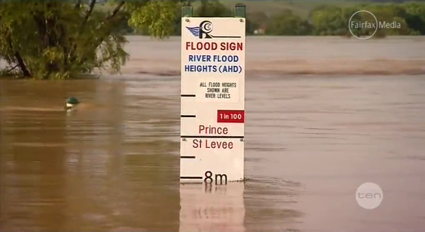
By Megan Levy
29 January 2013 (Sydney Morning Herald) – More than 2100 residents in Grafton have been ordered to evacuate on Tuesday as authorities prepare for the Clarence River to hit a record peak at midday which authorities warn will cause major flooding. The State Emergency Service issued a flood evacuation order for Dovedale and North Meadow at 8.30am, telling residents to leave their homes immediately. A further 7000 people in Grafton have been told to prepare to evacuate if conditions deteriorate further. Authorities originally expected the Clarence River in Grafton to peak at 7.9 metres about 9am on Tuesday. However, that later was revised up to an expected peak of 8.1 metres at midday, which was forecast to cause major flooding of downstream rural properties. Caroline Ortel, SES regional controller, said Grafton was facing record flood levels, which could be even higher than predicted.
“What we’re dealing with there is a flood of record,” she said. “There has never been a flood of this height in recorded history of Grafton, so for everybody who is trying to work on this and make all of the predictions, there isn’t historical data to go on. The river is showing signs of dropping further upstream and that is what we have to work with at the moment.” The Bureau of Meteorology has issued a major flood warning for the Clarence Valley, and a moderate flood warning for the Orara River. […] The flooding was due to heavy rain from the past few days flowing into the Clarence River upstream. At nearby Lilydale, the Clarence River peaked at 20.94 metres at midnight on Monday. That was close to the 1954 flood peak of 21 metres. [more]
Hundreds evacuated as Grafton braces for record flood 
By Nino Bucci
29 January 2013 (Sydney Morning Herald) – Firefighters in Victoria’s north-east are confident that containment lines will hold on Tuesday despite violent winds, but the bushfire near Violet Town could burn for weeks. The fire at Boho has burned 1448 hectares; there are 130 firefighters on scene. Winds are expected to reach 70 kilometres an hour on Tuesday, but a Country Fire Authority spokeswoman said firefighters in the area had spent much of Monday building containment lines and expected that the fire would be controlled. She said the fire could burn for some time as it is in steep, dense terrain. […] In Gippsland, a fire that started in Aberfeldy on January 17 is still burning, but is being controlled. [more]