April in January: Spring-like severe weather and record warmth in the U.S. Midwest – ‘Chicago’s craziest January in memory’
By Dr. Jeff Masters
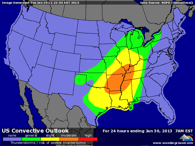
29 January 2013 (Weather Underground) – The calendar says it’s January, but the atmosphere looks more like April over the Midwest U.S., where a spring-like surge of warm air is interacting with a strong low pressure system to create a dangerous severe weather situation. The warm air surging northwards has already broken high temperature records for the date in Chicago, where the mercury hit 61°F [16°C] at 7 am CST; a tornado watch is posted for portions of Texas, Oklahoma, Kansas, and Arkansas. Golf-ball sized hail fell at three locations in Oklahoma already this morning, and a wind gust of 75 mph was reported in a thunderstorm near Omega, Oklahoma. NOAA’s Storm Prediction Center has placed portions of Arkansas, Louisiana, Texas, Tennessee, Missouri, Alabama, Oklahoma, Illinois, Indiana, and Mississippi in their “Moderate Risk” region for severe weather on Tuesday. This is the first “Moderate Risk” forecast issued during 2013. The primary threat will be damaging thunderstorm winds, but we will also see tornadoes, with the potential for a few strong EF-2 and EF-3 twisters. The surge of warm moving northwards ahead of the cold front spawning today’s severe weather is bringing in warmth unprecedented for January in some locations. Monday was the hottest January day on record in Topeka, Kansas, which hit 77°F [25°C]. That’s 36°F above average. and 3° warmer than their previous highest January temperature. Columbia, Missouri tied its all-time warmest January temperature, 77°F [25°C]. Kansas City (74°F [23.3°C]) and Wichita (74°F) both fell 1° short of tying their all-time January hottest temperature records. Balloon soundings of the atmosphere taken last night showed moisture levels in the top 5% for a January day over much of the Midwest, and several stations may set all-time rainiest January day records today. One candidate is Flint Michigan, where a heavy thunderstorm moved in at 7:30 am, dumping 0.75″ of rain. With another round of thunderstorms expected tonight, Flint is poised to break its record for rainiest January day in its history–the 1.34″ that fell on 18 January 1949. Chicago’s craziest January in memory got even stranger today, when a surge of warm air pushed the temperature to 61°F at 7 am, breaking the previous high temperature record of 59°F for the date. Spring-like thunderstorms, accompanied by temperatures in the mid-60s are expected this afternoon–just a week after the city recorded a high temperature of 11°F and a low of -1°F (on January 22nd.) Chicago has been above 65°F in January just once in its history–on January 25, 1950, when the mercury hit 67°F. [more]
April in January: spring-like severe weather and record warmth in the Midwest
