50 doomiest images of 2012
In 2011, Desdemona experienced déjà vu while collecting doom-laden images, but not so this year. Doom has begun to have a certain characteristic look: the record flooding looks the same, whether it’s in the Philippines or Nigeria; spiderwebs coat the flooded landscape in Pakistan and Australia alike. Mega-fires in Siberia and the U.S. West produce the same rivers of smoke, so gigantic that they’re visible from space. The desolation of razed rainforest is familiar in the Amazon and in Madagascar. The decaying corpses of poached wildlife in Africa evoke the same despair as drying shark fins in Hong Kong. So what’s new in 2012’s doom images? Here are a few highlights:
- Enterprising reporters took to the skies to photograph the wasteland of the Athabascan oil sands mines in more detail than we’ve seen before.
- A rare, powerful Arctic storm hovered over the pole and shredded what was left of the summer sea ice.
- Renegade geoengineer Russ George successfully created an artificial algae bloom off the coast of British Columbia.
- Some nominally Christian farmers in Kansas resorted to pagan appeals to bring rain. This effort had no effect on the devastating North America drought.
- Mutations appeared in wildlife near the Fukushima nuclear plant.
Most of all, Desdemona will remember 2012 for the ominous, orange summer sunlight in Seattle, as smoke from the Siberia mega-fires fell out over Washington state and British Columbia.

The sun sets behind Port Angeles City Pier, 9 July 2012. Smoke from wildfires in Siberia is producing spectacular sunsets. Keith Thorpe / Peninsula Daily News
Smoke from Siberia fires raises ozone levels in British Columbia to record levels
— 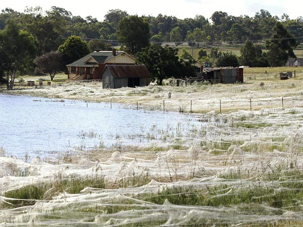
Spider webs cover the Australia landscape, 7 March 2012. After a week of record rain, floodwaters across eastern Australia have forced the ground-dwelling spiders – and at least 13,000 people – to flee their homes. The rampant webs blanketing vast stretches of Wagga Wagga are likely a dispersal mechanism that allows spiders to move out of places where they’d surely be drowned. Daniel Munoz / Reuters
Spiderwebs blanket countryside after Australia floods
— 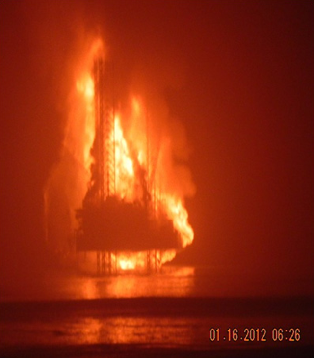 K.S. Endeavor jackup drilling rig burning off Nigeria’s coast on 16 January 2012. Photo: Chevron
Dead fish, health problems emerge as Chevron rig off Nigeria continues to burn after accident — 
A dying pelican crawled from the surf to die on the beach in Tumbes, Peru, near the border with Ecuador. Hundreds of dolphin and seabirds have been found dead on the beaches of Peru in 2011 and 2012. Silvia Oshiro / Agence France-Presse / Getty Images
Dead dolphins and birds are causing alarm in Peru
— 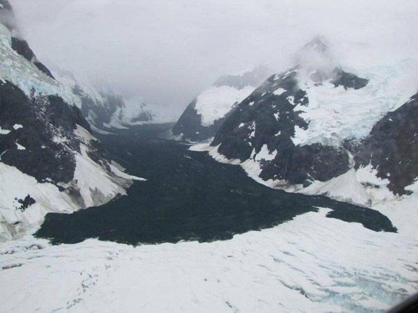
Aerial view of a landslide at Glacier Bay National Park in Alaska, 6 July 2012. The 11 June 2012 landslide might be the largest ever recorded in North America. Drake Olson / flydrake.com / AP Photo
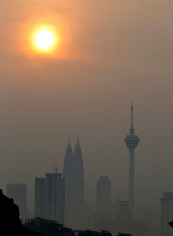
The Petronas Towers in Kuala Lumpur were engulfed in a haze from fires in Indonesia in June 2012. Mark Baker / Associated Press
Indonesia rainforest burning covers Southeast Asia in haze
—
Video: Waldo Canyon fire, 23-28 June 2012 — 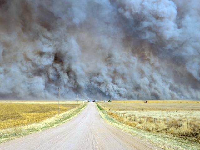
A wall of smoke blocks the sky from the Heartstrong Fire in Yuma County, Colorado, 18 March 2012. rammb.cira.colostate.edu
Are Western forests doomed to burn away?
— 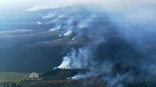
Aerial view of the Taylor Bridge fire in Washington state, 14 August 2012. NBC News
Firefighter killed as wildfires rage across the U.S. West
— 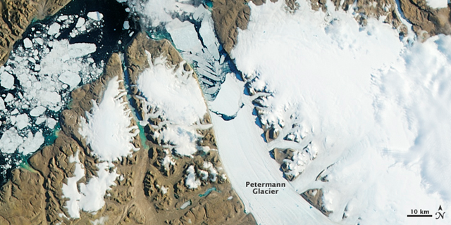
A massive iceberg, or ice island, broke off of the Petermann Glacier in 2010. Nearly two years later, another chunk of ice has broken free. The Moderate Resolution Imaging Spectroradiometer (MODIS) on NASA’s Aqua satellite observed the new iceberg calving and drifting downstream on 16–17 July 2012. NASA Earth Observatory image by Jesse Allen, using data from the Land Atmosphere Near real-time Capability for EOS (LANCE)
Image of the Day: Satellite view of iceberg calving from Petermann Glacier, 17 July 2012
— 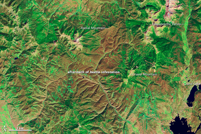
The Thematic Mapper on Landsat 5 acquired this image of lodgepole pine forests near Grand Lake, Colorado on 28 September 2011, after a severe bark beetle infestation led to die-off of the tree canopy. NASA Earth Observatory image created by Robert Simmon, using Landsat data provided by USGA
Image of the Day: Satellite view of Colorado forest destruction by beetles, 2005-2011
— 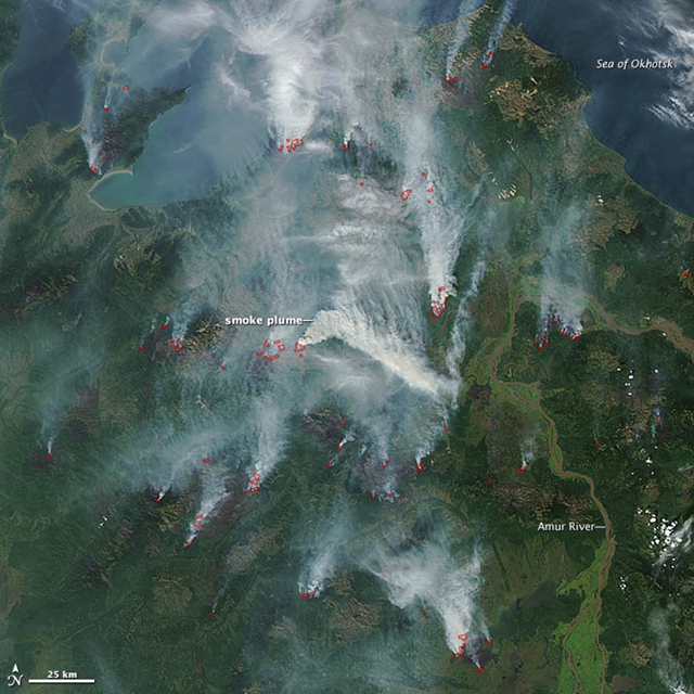
On 28 August 2012, the Moderate Resolution Imaging Spectroradiometer (MODIS) aboard NASA’s Aqua satellite acquired this natural-color satellite image of several wildfires burning in the Khabarovsk region of eastern Russia. Red outlines indicate hot spots where MODIS detected unusually warm surface temperatures associated with fires. Large fires have burned across Siberia throughout the summer. NASA image courtesy Jeff Schmaltz, LANCE MODIS Rapid Response
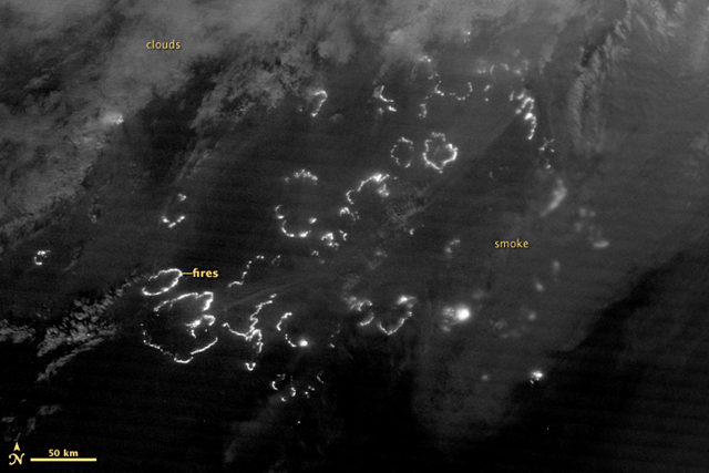
The Suomi National Polar-orbiting Partnership satellite (S-NPP) carries an instrument so sensitive to low light levels that it can detect wildfires in the middle of the night. On 3 August 2012, the Visible Infrared Imaging Radiometer Suite (VIIRS) on Suomi-NPP acquired the top image of wildfires blazing in eastern Siberia. The image is from the instrument’s “day-night band,” which sensed the fire in the visible portion of the spectrum. The brightest fires are white; smoke is light gray. earthobservatory.nasa.gov
Image of the Day: Nighttime satellite view of Siberia forest fires, 3 August 2012
— 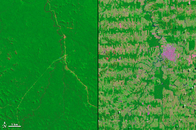
Deforestation in the Amazon Rainforest takes on many different patterns. In Rondônia, a state in Western Brazil, deforestation took on the fishbone pattern revealed in these Landsat images from 1975 and 2012. NASA images courtesy Landsat team
Image of the Day: Satellite view of deforestation in Rondônia, Brazil, 1975 and 2012
— 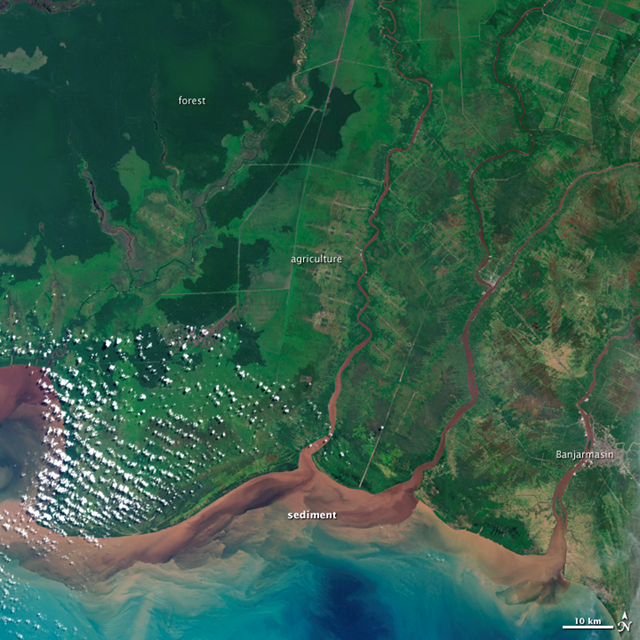
The image above shows a southern section of Kalimantan as it appeared on 16 July 2000. The natural-color view was acquired by the Enhanced Thematic Mapper Plus (ETM+) on the Landsat 7 satellite. Light green areas with gridlines of light brown show portions of rainforest that were cleared for palm oil plantations and roads. Dark greens show the remaining rainforest. NASA image by Jesse Allen, Robert Simmon, and Michael Taylor, using data from the USGS Global Visualization Viewer
Image of the Day: Satellite view of deforestation in Kalimantan, Borneo, Indonesia
— 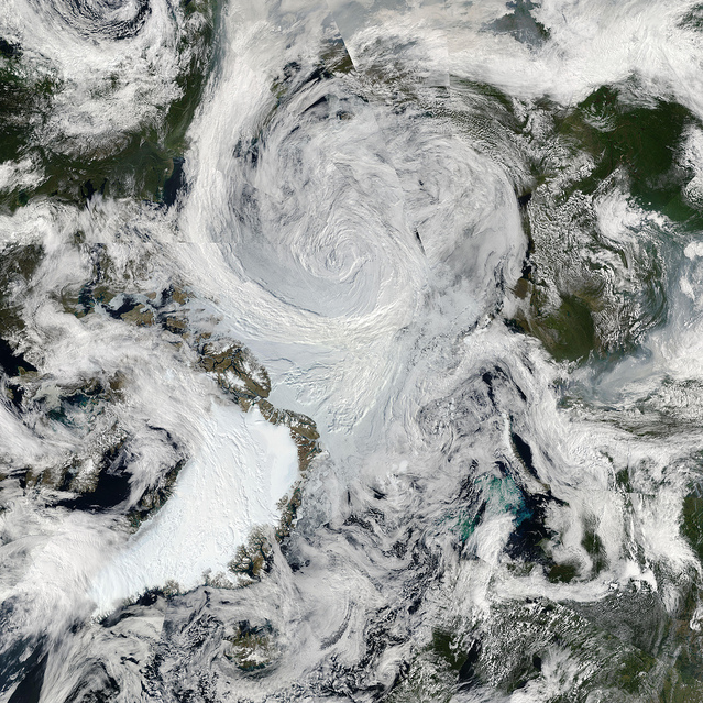
An unusually strong storm formed off the coast of Alaska on 5 August 2012 and tracked into the center of the Arctic Ocean, where it slowly dissipated over the next several days. The Moderate Resolution Imaging Spectroradiometer (MODIS) on NASA’s Aqua satellite captured this natural-color mosaic image on 6 August 2012. The center of the storm at that date was located in the middle of the Arctic Ocean. NASA Goddard Space Flight Center
Image of the Day: Satellite view of unusually strong Arctic storm, 6 August 2012
— 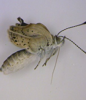
Adult pale grass blue (Zizeeria maha) butterflies from the Fukushima area show numerous mutations. Otaki, et al., 2012 via BBC
‘Severe abnormalities’ found in Fukushima butterflies
— 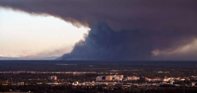
In this 22 August 2012 photo, smoke from the Dry Creek Fire spreads through the sky after it rekindled from a June 23 lightning strike in Fairbanks, Alaska. The fire, 25 miles south of Fairbanks, Alaska, was mapped by a surveillance flight Wednesday. At 28,251 acres, the fire has doubled in size since Sunday. Sam Harrel / AP Photo / Fairbanks Daily News-Miner
Wildfire rages unchecked in Alaska as blankets of black smoke shrouds Fairbanks area
— 
A billboard, Jesus in the Wheat, stands alongside Interstate 70 on 24 August 2012 in Colby, Kansas. The billboard was erected by local residents Tuffy and Linda Taylor. “We just put it up there to minister”, Linda Taylor told the Hays Daily News. CNN
From dry rivers to dead deer, U.S. drought impact felt everywhere
— 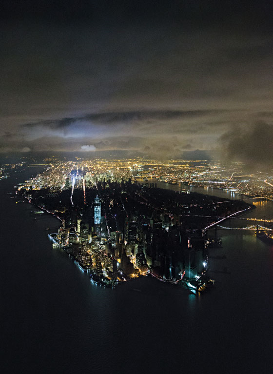
Aerial view of blackout on Manhattan Island after Hurricane Sandy, featured on the cover of the 4 November 2012 issue of New York Magazine. Iwan Baan / New York Magazine
Image of the Day: Aerial view of blackout on Manhattan Island after Hurricane Sandy
— 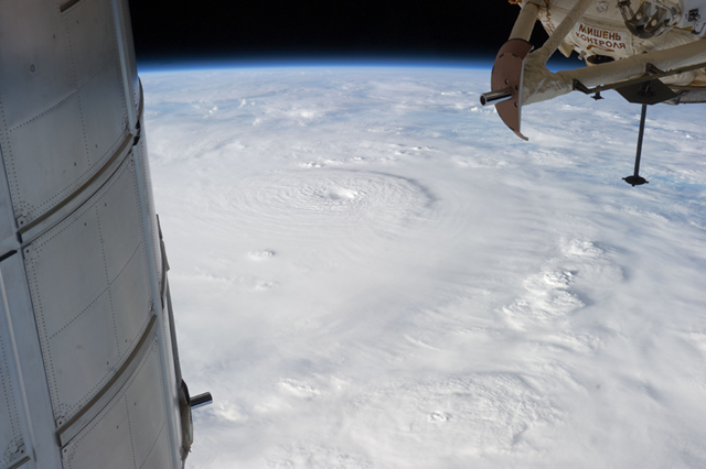
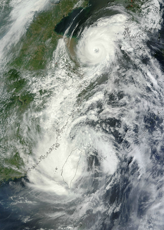
Typhoon Bopha is shown moving toward the Philippines from the International Space Station, 2 December 2012. The typhoon slammed into the Davao region of the Philippines early on 4 Decemer 2012, killing hundreds and forcing more than 50,000 to flee from inundated villages. NASA / Associated Press
Photo gallery: The wake of Typhoon Bopha in the Philippines
— 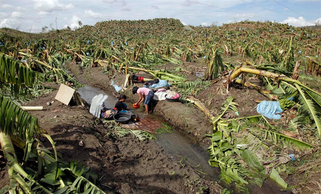
Villagers wash their clothes amidst a destroyed banana plantation after Typhoon Bopha hit Compostela Valley, southern Philippines, 5 December 2012. Erik De Castro / Reuters
Death toll from Typhoon Bopha tops 500 in Philippines
— 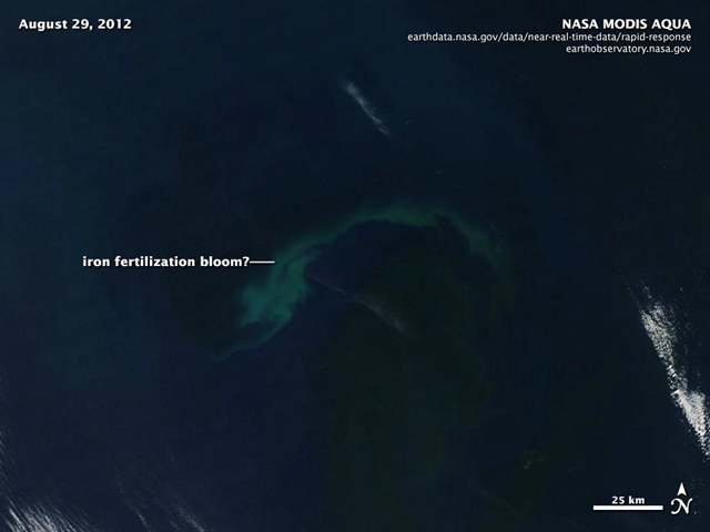
Satellite view of possible phytoplankton bloom caused by Russ George’s rogue iron fertilization experiment, 29 August 2012. NASA / MODIS / AQUA
Rogue geoengineering project: Can we stop modern-day mad scientists?
— 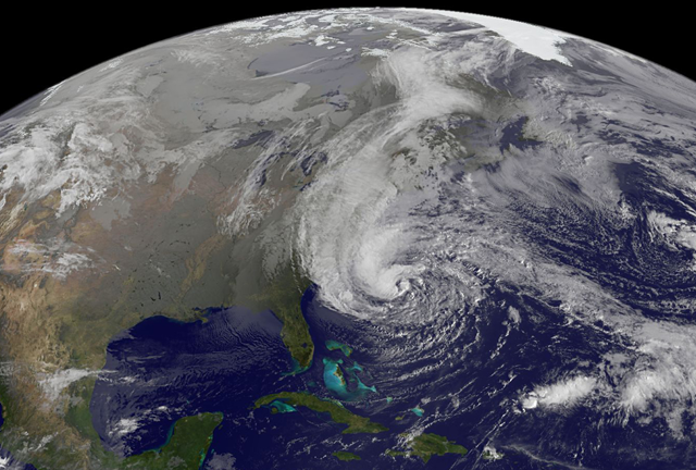
Satellite view of Hurricane Sandy, at 9:02 am EST on 28 October 2012. NASA GOES Project
UN climate scientist: Sandy no coincidence
— 
This image of Hurricane Sandy was acquired by the Visible Infrared Imaging Radiometer Suite (VIIRS) on the Suomi NPP satellite at 2:42 a.m. Eastern Daylight Time (06:42 Universal Time) on 28 October 2012. NASA Earth Observatory image by Jesse Allen and Robert Simmon

SEM images of juvenile L. helicina antarctica (from which the periostracum has been removed) showing different levels of dissolution. a,b, Intact animal without any indications of dissolution. c, Level I: the upper prismatic layer slightly dissolved. d, Level II: the prismatic layer partially or completely missing and the cross-lamellar matrix partially exposed. Bednaršek, et al., 2012
Rising acidity levels threaten ocean food chain, study finds
— 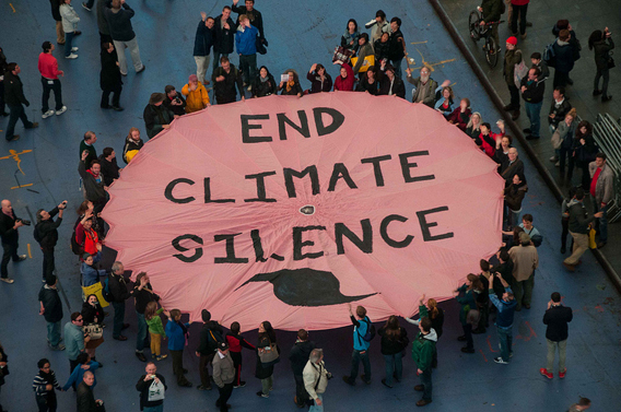
Activists protest climate silence in New York City, one day before Hurricane Sandy makes landfall, 28 October 2012. 350.org
Hours before Hurricane Sandy hit, activists protested climate inaction in Times Square
— 
Tropical Storm Saola and Typhoon Damrey appear on NASA satellite imagery to be arm-in-arm as they enter China on 2 August 2012. NASA’s Terra satellite passed over both tropical cyclones and captured them in one image, using the Moderate Resolution Imaging Spectroradiometer (MODIS) instrument onboard. NASA Goddard MODIS Rapid Response Team
China braces for record third typhoon in a week
— 
Labourers work to repair downed power lines after pylons were toppled by Typhoon Haikui in Wenling, Zhejiang province on 8 August 2012. REUTERS / China Daily
Nearly 2 million evacuated as Typhoon Haikui hits China – Reservoir collapse kills at least 10
— 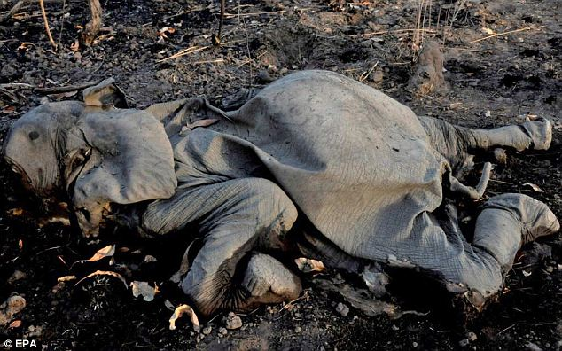
According to The International Fund for Animal Welfare (IFAW), poachers slaughtered 300-400 elephants for their tusks in Cameroon since 2012, up to 200 in a single park. Here is just one of the dead. EPA via dailymail.co.uk

Design for condoms that highlight human overpopulation, given away in all 50 U.S. states, on 80 college campuses, Safe intercourse saves the dwarf seahorse. endangeredspeciescondoms.com / biologicaldiversity.org
100,000 endangered species condoms to be given away for Earth Day
— 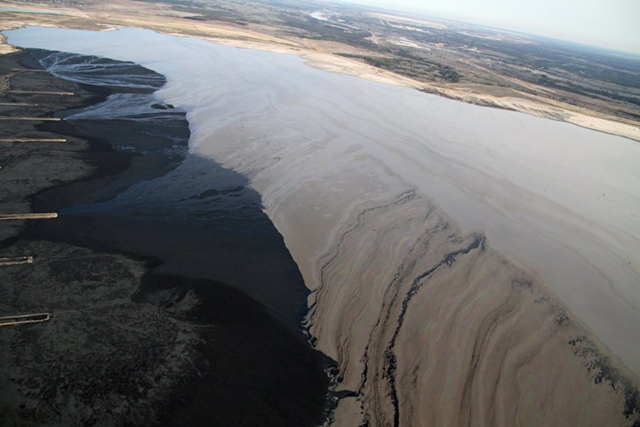
Aerial view of tailings ponds at the Athabascan Oil Sands in Alberta, Canada, 18 May 2012. A mixture of water and oil sand from the strip mines is called ‘slurry’. The sand and water mixture is pumped to open storage areas called tailings ponds. The ponds are vast and some look more like lakes. Most ponds are coated in a sheen of oil that is deadly to waterfowl, like ducks and geese, that land on its surface. Robert Johnson / businessinsider.com
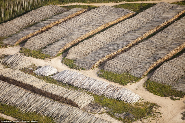
Aerial view of stacks of boreal forest trees that were cut to make way for the Alberta Tar Sands mine, 17 October 2012. Ashley Cooper
Photo gallery: Aerial view of deforestation at the Tar Sands mine in Alberta, Canada
— 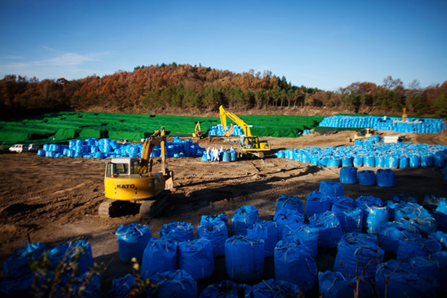
Cleanup in Kawauchi, a village in Fukushima Prefecture. In Okuma, decontamination efforts have been slow to reduce radiation dosages, and hopes of returning to their ancestral lands have faded for evacuated residents. Ko Sasaki for The New York Times
Hopes of returning home fade among Japan’s Fukushima refugees
— 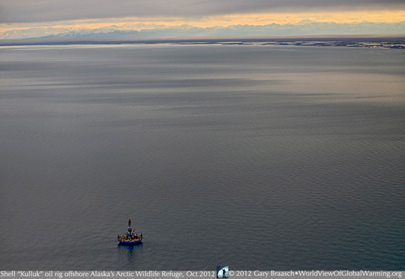
The Royal Dutch Shell drilling rig Kulluk off the coast of the Arctic National Wildlife Refuge. The Kulluk ran aground off the Alaskan coast, near Sitkalidak Island on the north edge of Ocean Bay, on 31 December 2012. Gary Braasch / worldviewofglobalwarming.org
Image of the Day: Shell drilling rig within view of the Arctic National Wildlife Refuge
— 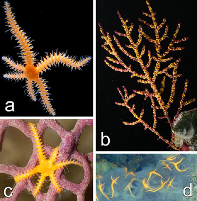
Los Angeles California, 20 August 2012 (SPX) – Coral Reefs, the Journal of the International Society for Reef Studies, has published online a study co-written by Dr. Gordon Hendler of the Natural History Museum of Los Angeles County (NHM) about an invasive species of brittle star, Ophiothela mirabilis. The species was previously restricted to Pacific waters, but surprisingly, growing populations have established themselves at distant points in the Atlantic. Its presence near Brazilian and Caribbean ports indicates that O. mirabilis could have been spread by shipping. “I imagine that when my grandchildren learn to scuba dive,” Hendler says, “Caribbean reefs will look very different than they do today, in part because many corals and sponges may be covered with a network of invasive yellow brittle stars.”
Invasive brittle star species hits Atlantic Ocean, threatens coral reefs
— 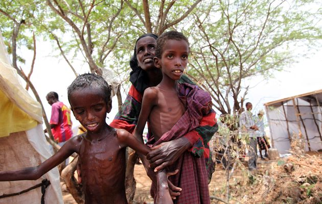
An internally displaced woman attends to her malnourished children outside their makeshift shelter at a temporary camp in Hodan district of Somalia’s capital Mogadishu, 26 August 2011. FEISAL OMAR / REUTERS
Yemen’s children caught in food crisis – ‘This is the worst crisis faced by Yemen in my lifetime’
— 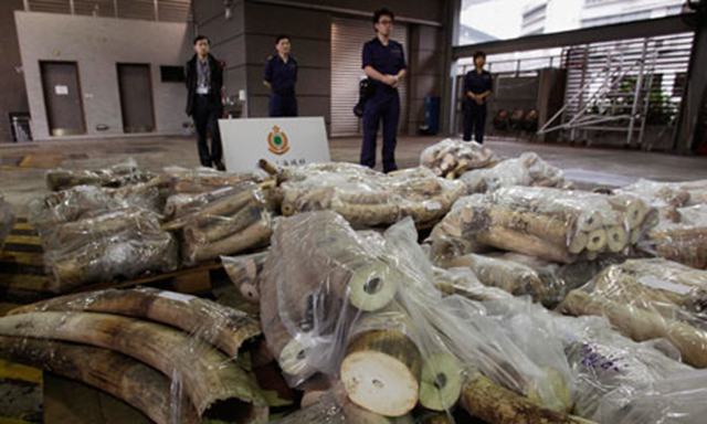
Hong Kong customs officers guard 45 bags of unprocessed ivory, which had been concealed in more than 400 bags of sunflower seeds. They discovered the ivory, taken from over 200 poached elephants, on 15 November 2012. The seizure comes just two weeks after customs officers in Hong Kong discovered almost 4 tons of ivory representing 600 poached elephants. Bobby Yip / Reuters
Hong Kong customs seize over a ton of smuggled ivory, one month after record 4-ton seizure
— 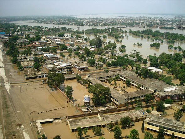
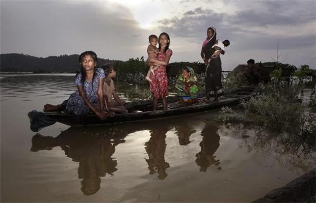
Aerial view of flooding in Sindh province, Pakistan, 1 October 2012. pardaphash.com
Over 450 dead, 4.5 million people hit in Pakistan floods
— 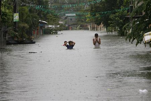
Children cross floodwaters at a submerged main street in Calumpit town, Bulacan province, north of Manila, 9 August 2012. Romeo Ranoco / Reuters
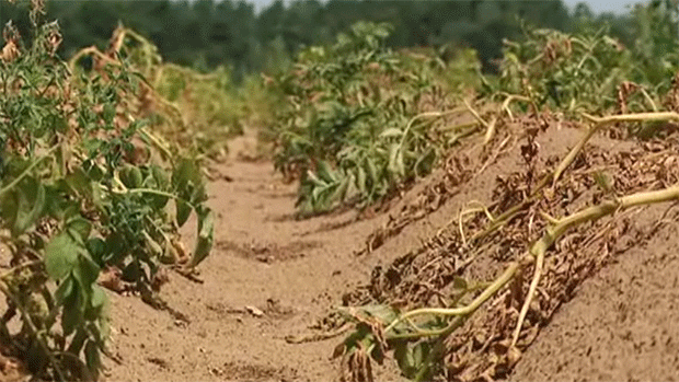
Crops wilt in a field in Canada, 15 July 2012. A lack of rain and extremely hot temperatures badly affecting crops mean that Canadian consumers will likely be paying more for their produce. CBC
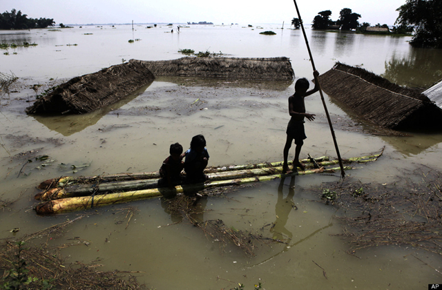
Indian children use a raft, made of banana plants, to wade through flood waters at Burhaburhi village, about 65 kilometers (40 miles) east of Guahati, India, 29 June 2012. Anupam Nath / AP Photo
Fresh flooding threatens northeast India
— 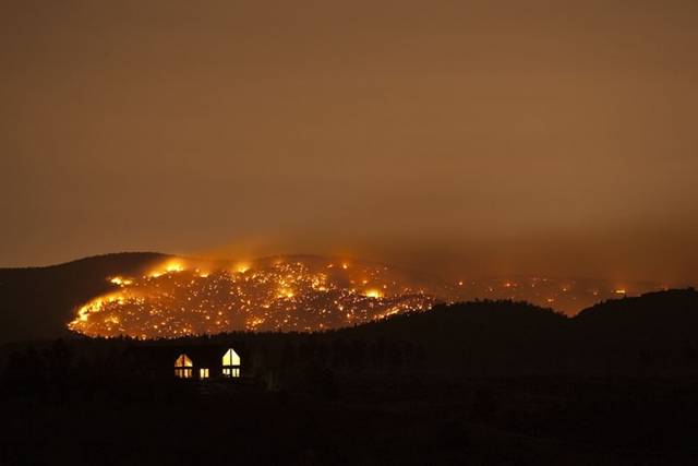
North Fork fire in Conifer, Colorado, March 2012. Dean Barr
This U.S. summer is ‘what global warming looks like’
— 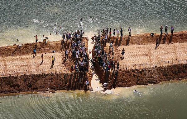
Aerial view of protesters at the Belo Monte dam site in Brazil. Mario Tama / Getty Images
A flood-affected family sits on a boat surrounded with floodwaters at Tin Tukra about 35 kilometers (22 miles) east of Gauhati, India, Saturday, 30 June 2012. Officials in northeastern India are on alert for poachers after surging flood waters forced endangered rhinos, Asiatic elephants, a variety of deer and other animals. Anupam Nath / AP Photo

City green belt in Karbala Province. iraqphoenix.com
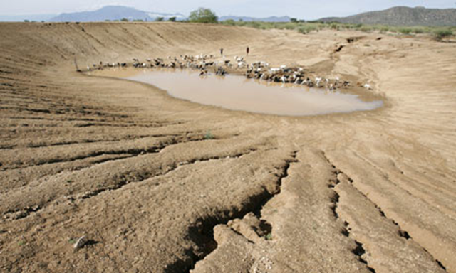
Nomadic pastoralists Turkana tribesmen herd goats and sheep to an almost dry dam on the outskirts of Gakong, in northwestern Kenya. Stephen Morrison / EPA
Kenya’s bid to become the first African nation to set up a climate authority
— 
A building in Athens is engulfed in flames during the demonstration against Greece’s new austerity measures, 12 February 2012. Vladimir Rys / Getty Images
Secret Central Bank aid props up Greek banks
— 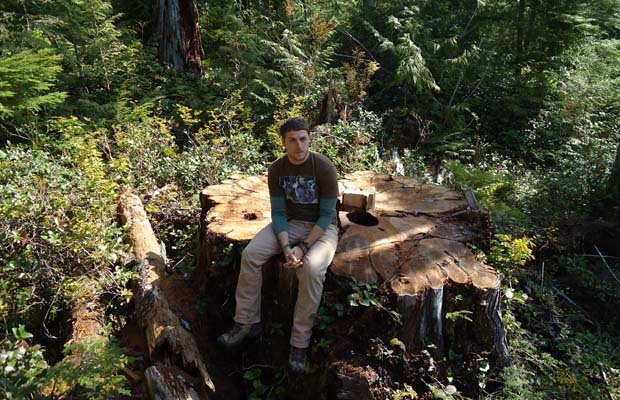
Torrance Coste on the site where tree poachers have dragged a massive 800-year-old western red cedar through the underbrush at Carmanah Walbran Provincial Park, damaging plants and other trees, on 17 May 2012. The thieves previously cut partially through the tree, forcing B.C. Parks to fell it because it had become a hazard. Photo courtesy Torrance Coste / Victoria Times Colonist
Poachers cut down, steal giant 800-year-old red cedar in B.C. park
— 
The past century has been defined by an epic migration of people from rural areas to the city. In 2008, for the first time in history, more of the Earth’s population was living in cities than in the countryside. The U.N. now predicts that nearly 70% of the global population will be city dwellers by 2050. Looking back through the decades, these snapshots from space — created exclusively for CNN by NASA’s Landsat department in collaboration with the U.S. Geological Survey – reveal the impact of this vast population shift on cities around the world.
Photo gallery: Images from space track relentless spread of humanity
— 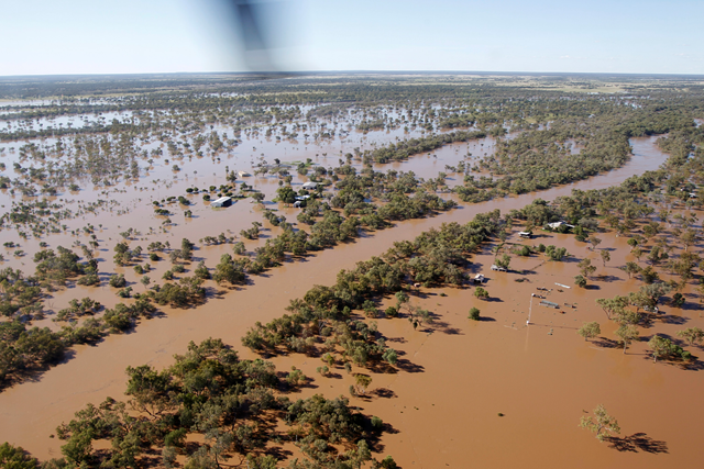
In this photo released by The Royal Australian Air Force, an Australian Air Force helicopter flies over flooded property during an evacuation of flood victims, 29 miles south of Charleville in Queensland state, Australia, Monday, 6 February 2012. AP PHOTO / ROYAL AUSTRALIAN AIR FORCE, LEADING AIRCRAFTMAN BENJAMIN EVANS

A billboard in Chicago, paid for by The Heartland Institute, along the inbound Eisenhower Expressway in Maywood, Illinois, 4 May 2012. The billboards compare supporters of climate science to Ted Kaczynski, Charles Manson, and Fidel Castro. Photograph: The Heartland Institute
Heartland Institute billboards compare belief in global warming to mass murder