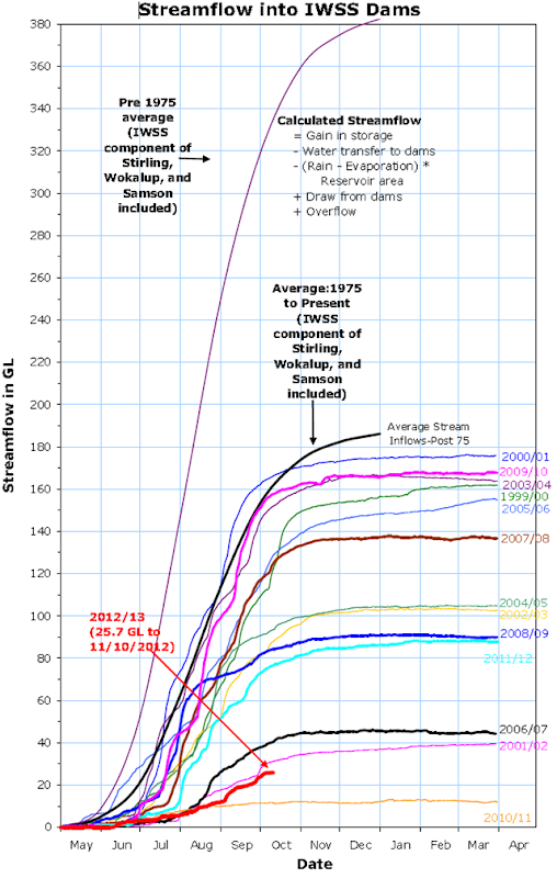
Graph of the Day: Streamflow into Perth Area Dams, 2000-2012
The Perth water supply area is 3,266 km2 and lies within the Perth Basin, occupying part of the Swan Coastal Plain and Dandaragan Plateau. Bounded in the north by the northern boundary of the Gnangara GMA, and in the south by the southern boundary of the Serpentine and Rockingham GMUs, the water supply area encompasses the Cockburn and Jandakot GMUs, as well as the Gnangara Mound, [Link to Gnangara Mound section 9.2] (Davidson and Yu, 2006; Department of Water, 2006).
The Department of Water is the agency responsible for managing all of Western Australia’s water resources, assessing licence applications for water abstraction from private users, local governments and water service providers. The Integrated Water Supply Scheme (IWSS) supplies water to a population of 1.5 million and is managed by the Water Corporation. The scheme services towns in the South West and metropolitan Perth, as well as towns and farmlands in the Central Wheatbelt out to Kalgoorlie Boulder through the Goldfields Pipeline from Mundaring Weir (Water Corporation, 2005). Figure 2 shows the major groundwater sources, major dams and the water supply distribution network within the Perth water supply area. As illustrated, the IWSS is supplied from multiple groundwater and surface water sources located over a wide geographic area. From October 2006 sources will be supplemented with a further 45 gigalitres of water annually from the Perth Seawater Desalination Plant (Water Corporation, 2005).
