Typhoon Jelawat to impact 100 million people
By Alex Sosnowski, Expert Senior Meteorologist
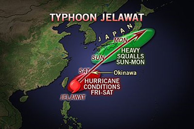
28 September 2012 Jelawat in the Western Pacific is forecast to curve across Okinawa and the Japan mainland, bringing flooding rain, monstrous seas, and damaging winds. According to World Weather Expert Jason Nicholls, “It has turned northward as forecast and is projected to turn northeastward this weekend with direct, dangerous impacts on Japan.” As of Friday, Jelawat is no longer a super typhoon. Jelawat was cruising north-northeast of the island of Luzon in the Philippines Friday with maximum sustained winds of 130 mph and gusts to 160 mph. Estimated seas near and just northeast of the center of circulation were around 40 feet. The AccuWeather.com Hurricane Center has the latest statistics on Jelawat. While not making a direct hit on Tawain, Jelawat has delivered over a foot of rain on some of the mountains in the islands as of Friday, 28 September 2012, midday EDT. Jelawat will track through progressively cooler waters and drier air. Both will work to weaken Jelawat somewhat before reaching the Ryukyu Islands, but the system will remain quite strong over deep warm water into the end of the week. […] “People and interests in the Ryukyu Islands, including Okinawa, should be prepared for a direct hit with an accelerating tropical cyclone of typhoon or hurricane strength,” Nichols said. “The islands can be subject to damaging winds in excess of 100 mph, dangerous surf and seas and torrential rain and flooding.” Impact will begin on the Ryukyu Islands early this weekend with building seas, increasing wind and squalls with the worst conditions Sunday, local time, and late Saturday EDT. By the time the system reaches the latitude of mainland Japan early next week, it may be a tropical storm or transitioning to a non-tropical system. “Despite the projected weakening before hitting mainland Japan, the terrain may squeeze one to two feet of rain in some areas, potentially leading to major flooding,” Nicholls added. Tropical storm conditions are possible in Tokyo Monday into Tuesday, local time. If Jelawat were to track northwest of Tokyo, the city could be hit by damaging wind. If the storm were to pass just to the southeast of the city, the metro area could be hammered by flash and urban flooding. Regardless, much of mainland Japan is heavily populated and there is the potential for damage and loss of life with Jelawat. […] Jelawat is the second storm to reach the equivalent of a Category 5 hurricane in the Western Pacific this season. Sanba was the first.