Report: The Age of Western Wildfires
18 September 2012 (Climate Central) – The 2012 wildfire season isn’t over yet, but already this year is shaping up to be the one of the worst on record in the American West. According to the National Interagency Fire Center, with nearly two months still to go in the fire season, the total area already burned this year is 30 percent more than in an average year, and fires have consumed more than 8.6 million acres, an area larger than the state of Maryland. Yet, what defines a “typical” wildfire year in the West is changing. In the past 40 years, rising spring and summer temperatures, along with shrinking winter snowpack, have increased the risk of wildfires in most parts of the West. Studies show that continued climate change is going to make wildfires much more common in the coming decades. The National Research Council reports that for every degree Celsius (1.8oF) of temperature increase, the size of the area burned in the Western U.S. could quadruple. According to the IPCC 4th Assessment Report, summer temperatures in western North America could increase between 3.6oF and 9oF by the middle of this century. Our analysis [pdf] of 42 years of U.S. Forest Service records for 11 Western states shows that: The number of large and very large fires on Forest Service land is increasingly dramatically. Compared to the average year in the 1970’s, in the past decade there were:
- 7 times more fires greater than 10,000 acres each year
- Nearly 5 times more fires larger than 25,000 acres each year
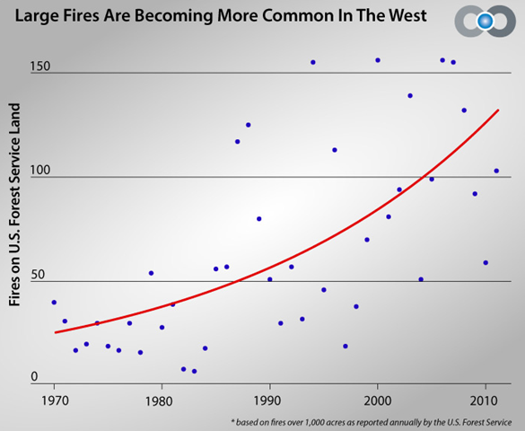
- Twice as many fires over 1,000 acres each year, with an average of more than 100 per year from 2002 through 2011, compared with less than 50 during the 1970’s.
In some states the increase in wildfires is even more dramatic. Since the 1970’s the average number of fires over 1,000 acres each year has nearly quadrupled in Arizona and Idaho, and has doubled in California, Colorado, Montana, New Mexico, Nevada, Oregon, Utah, and Wyoming. On average, wildfires burn twice as much land area each year as they did 40 years ago. In the past decade, the average annual burn area on Forest Service land in the West has exceeded 2 million acres — more than all of Yellowstone National Park. The burn season is two and a half months longer than 40 years ago. Across the West, the first wildfires of the year are starting earlier and the last fires of the year are starting later, making typical fire years 75 days longer now than they were 40 years ago. Rising spring and summer temperatures across the West appear to be correlated to the increasing size and numbers of wildfires. Spring and summer temperatures have increased more rapidly across this region than the rest of the country, in recent decades. Since 1970, years with above-average spring and summer temperatures were typically years with the biggest wildfires. Previous research reveals that climatic changes, including increasing temperatures and the earlier onset of spring snowmelt, have been linked to increasing levels of atmospheric greenhouse gases and are likely influencing these damaging fire trends. As average global temperatures rise, researchers project that the risk of wildfires in America’s West will accelerate.