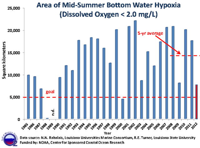
Graph of the Day: Area of Mid-Summer Bottom Water Hypoxia in the Gulf of Mexico, 1985-2012
Record drought across the United States in 2012 followed a year of record flooding in the Mid-West in 2011, producing two very different areas of hypoxia, or oxygen deficient water, on the Louisiana continental shelf. The 2012 area of low oxygen, commonly known as the ‘Dead Zone,’ measured 7,480 square kilometers (= 2,889 square miles) in this summer’s mapping expedition. This is the fourth smallest area of hypoxia measured since the mapping began in 1985. The smaller area reflects the drought conditions across the US in that the freshwater discharge and associated nutrients delivered to the Gulf of Mexico was mostly below average in spring and approached the 80-year minimum discharge as the mapping cruise neared its end. Chief Scientist, Dr. Nancy Rabalais, reported that “the smaller area was expected this July 2012, but the distribution across the shelf differed from any other documented to date.” There was a narrow band close to the Mississippi River and large, non-hypoxic area between there and the Atchafalaya River. From the Atchafalaya River to the west, there were one to three stations on each line from there to off Galveston Island in water depths mostly of 15 to 20 m. Low oxygen (hypoxia is dissolved oxygen < 2 milligrams per liter, or 2 ppm) was present as early as April 2012 and was also severely low up to mid-June off Terrebonne Bay, illustrating that the Mississippi River nutrients stimulated the production of phytoplankton in spring. The minimal continued freshwater discharge into July was not sufficient to maintain the stratification (layering of the water column) that prevents oxygen from the surface waters moving into the bottom waters to balance loss by bacterial decomposition of organic matter.
