China declares emergency as two typhoons close in – Typhoon Tembin to dump 1 meter of rain in Taiwan mountains – Typhoon Bolaven to be strongest storm yet this season
23 August 2012
By Wang Qian (China Daily) – Two powerful typhoons are heading toward China, putting the weather-beaten nation on alert again after four storms have caused landfalls across the country since the start of August. “Typhoons Tembin and Bolaven may have a combined impact on coastal areas in the coming 10 days,” Zhang Chang’an, chief forecaster at the China Meteorological Administration, said on Wednesday. Both storms are strengthening, with Bolaven expected to be the strongest typhoon to hit China this year if it lands in the country, Zhang said, adding that the storm will bring maximum winds of 220 km/h. The National Commission on Disaster Reduction issued a typhoon alert on Wednesday, warning authorities to make emergency plans. Tembin was about 2,000 km from the coast of Zhejiang province on Wednesday, moving at a speed of 5 km/h. The administration has asked authorities in potential affected areas to set up warning signs in high-risk areas such as construction sites and low-lying areas, and open emergency shelters including schools and stadiums for evacuation of affected people. The Fujian Meteorological Bureau urged boats to take shelter in ports by Wednesday to avoid possible damage brought by Tembin. Tembin, expected to be the fifth storm to hit China this summer, is expected to sweep across Taiwan on Thursday and continue toward the mainland, bringing rainstorms to Fujian and Guangdong provinces by the end of the week, according to the administration’s Shanghai Typhoon Institute. Bolaven is expected to bring torrential rain and strong winds to Shanghai and Zhejiang, Jiangsu, Shandong, Liaoning, and Jilin provinces between Aug 27 and 29, the administration said. Zhang said satellite images show Bolaven will become the strongest typhoon formed in this typhoon season, which may cause catastrophic damage. The previous typhoon – Kai-Tak – claimed three lives and one person is still missing, with nearly 3 million people affected in the Guangxi Zhuang autonomous region by Tuesday, according to the region’s civil affairs bureau. Since the start of August, three other typhoons, Saola, Damrey and Haikui, caused landfalls in China. That means the country could be hit by six typhoons in August, exceeding the record high five storms in 1994 and 1995. “The relatively high water temperature in the Western Pacific this year caused active heat convection, prone to form tropical storms,” said Gao Shuanzhu, senior engineer of the administration’s typhoon and marine meteorological forecast center. So far, 15 tropical storms have formed in the Western Pacific this year, two more than the average number in the same period for the past two decades.
Two typhoons to hit coastal areas 
By Lee Hsin-Yin
22 August 2012
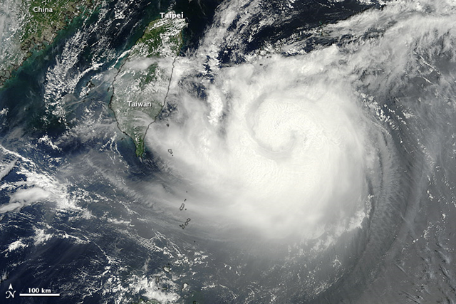
Taipei (CNA) – The Central Weather Bureau issued a land warning for Typhoon Tembin early Wednesday, warning of extreme rainfall and strong winds in eastern Taiwan beginning later in the day. As of 12 p.m., Tembin was located 330 kilometers east of Taitung, moving at a speed of 9 km per hour in a west-northwesterly direction. It was packing sustained winds of 144 kph, with gusts reaching 180 kph, the bureau said. Describing Tembin’s structure as “solid,” the bureau said the storm will move closer to land between Wednesday and Thursday and pose a considerable threat to the entire island until Friday. The typhoon is expected to make landfall in eastern Taiwan on Thursday and hit the area with extreme rainfall, while gusts between 50 and 90 kph could be felt in the area after midnight, the bureau said. The bureau predicted that the accumulated precipitation from Tembin could reach some 1,000 millimeters in mountainous areas in eastern Taiwan. Low-lying areas in northern and southern Taiwan can expect accumulated rainfall of 100-400 mm and 300-600 mm, respectively. […]
Taiwan issues land warning for Typhoon Tembin 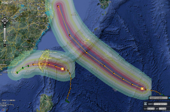
22 August 2012 (Xinhua) – An emergency response plan to cope with two approaching typhoons was launched by the National Commission for Disaster Reduction (NCDR) on Wednesday. The NCDR has urged civil affairs offices in coastal provinces and the three central provinces of Henan, Hubei and Hunan to prepare for typhoons Tembin and Bolaven. Disaster relief material reserve agencies in eight major cities in coastal and central China have also been told to prepare. Civil affairs authorities at all levels have been told to track the locations of the storms and their development, and release warnings and disaster prevention messages to the public via media channels. Disaster relief agencies should work with railway and other transport departments and ensure relief materials arrive in time, the NCDR said. The NCDR has called for thorough safety checks in harbors, low-lying areas, mountainous regions, construction sites, schools and tourist attractions and asked local authorities to prepare shelters in case residents need to be relocated. The commission required civil affairs authorities to stand alert and strengthen prevention efforts as more areas will be prone to natural disasters triggered by heavy rainfalls. Typhoons Tembin and Bolaven are the 14th and 15th named storms of the 2012 Pacific typhoon season. At 8:00 a.m. Wednesday, Bolaven was 2,027 km southeast of the eastern Zhejiang Province. It is expected to gather force as it moves toward eastern China at a speed of 15 km per hour, according to local meteorological authorities. To cope with Bolaven, the city of Wenzhou on Tuesday activated a level IV emergency response, the lowest-level emergency response plan in China’s four-level emergency response system. Tembin has brought heavy rains to the northern Philippines, killing a teenager and triggering landslides and flash floods that have displaced thousands. […]