U.S. drought of 2012 rivals Dust Bowl
By Nick Wiltgen
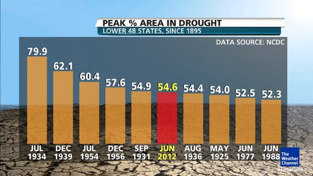
16 July 2012 The 2012 drought disaster is now the largest in over 50 years, and among the ten largest of the past century, according to a new report released by the National Climatic Data Center today. As The Weather Channel reported in an exclusive preview of the report Sunday, data computed from the Palmer Drought Severity Index shows that 54.6 percent of the contiguous 48 states was in drought at the end of June, the highest percentage since December 1956, and the sixth-highest peak percentage on record. The June State of the Climate drought report from NCDC, released today, shows that in records dating to 1895, only the extraordinary droughts of the 1930s and 1950s have covered more land area than the current drought. And by a slight margin, the current drought actually covers more area than the famous 1936 drought, though other droughts in the Dust Bowl years – particularly the extreme drought of 1934 – still rank higher. However, when excluding areas in “moderate” drought, the historical rankings change a bit. Some historical droughts were extremely intense, but more focused on specific regions rather than sprawling across large swaths of the country. For example, infamous droughts in 1988, 2000, and 2002 each included over 35% of the country in the “severe” to “extreme” drought categories on the Palmer drought scale. By comparison, severe to extreme drought covers 32.7% in June 2012. In short, the overall 2012 drought now covers more territory than any drought since the 1950s; but the more severe drought categories don’t cover quite as much land now as did the droughts of 1988 and the early 2000s. That being said, the 2012 drought still ranks as the 10th-largest severe drought since 1895, even by that stricter definition. […]