Japan officials failed to use U.S. data tracking radiation after Fukushima meltdown
By HIROKO TABUCHI
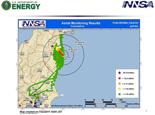
19 June 2012 TOKYO – The United States shared detailed radiation measurements with Japan in the early days of the 2011 Fukushima Daiichi nuclear disaster that the Japanese government did not make public or use in conducting evacuations, officials acknowledged on Tuesday. Lacking information about the direction of airborne particles, some evacuees fled, unknowingly, into the path of the radioactive plume. Others stayed for more than a month in areas with high radiation, because they lay beyond the government-imposed 12-mile evacuation zone. Trade Minister Yukio Edano, who oversees Japan’s nuclear regulator, the Nuclear and Industrial Safety Agency, apologized Tuesday for the blunder. “It is extremely regrettable that the government did not appropriately share or use the information, and I feel remorse toward the victims,” Mr. Edano said at a news conference. It is unknown whether the government’s failure to release the data as soon as it was available threatened the health of any civilians. The failure is being seen by critics in Japan as another example of the government’s early attempts to play down the severity of the accident by withholding damaging information. Government officials also withheld forecasts from a computer system that calculates the spread of radiation because they believed that the estimates were incomplete and inaccurate. Starting on March 17, 2011, as residents fled from the areas around the tsunami-stricken Fukushima Daiichi nuclear power plant, the United States sent aircraft to measure radiation levels in the vicinity, according to the Energy Department. The Energy Department then used the data, collected from over 40 hours of flight time over Fukushima, to compile a detailed map that showed an area of high radiation extending northwest from the plant. Measurements “show an area of greater radiation extending northwest from the accident,” materials accompanying the map warned. “This area may be of interest to public safety officials and responders.” According to Japanese officials, the United States government shared the data with Japan’s Foreign Ministry through its embassy in Tokyo on March 18, a day after helicopters frantically dropped water on a blown-out reactor building to keep spent fuel rods there from overheating. The Foreign Ministry immediately alerted the nuclear safety agency to the radiation readings, according to Masaru Sato, director of the ministry’s international press division. But it is unclear what happened next. There is no indication that the nuclear safety agency shared that data with Naoto Kan, the prime minister at the time, or other high-ranking officials, or that it used the maps to guide evacuations. […]
Japanese Officials Failed to Use U.S. Data Tracking Radiation After Tsunami
