How to track Colorado’s Waldo Canyon ‘super fire’ (and others)
By Matt Peckham
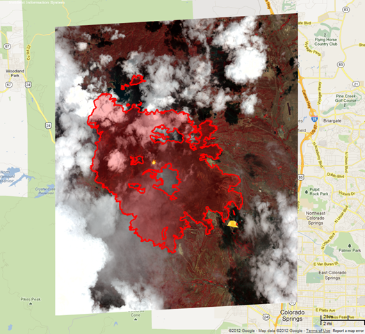
29 June 2012 As an uncontrolled “super fire” near Colorado Springs rages, feeding off parched terrain and forcing tens of thousands from their homes and businesses, high-tech mapping tools are dishing up highly detailed, bird’s eye views of the fire’s scope. Such tools offer everything from perimeter reports and pictures of the devastation to evacuation areas and shelters for both people and pets in the fire’s path. (PHOTOS: Wildfires Whip Through Colorado) Visit something called Google Crisis Response — an official Google website designed “to make critical information more accessible around natural disasters and humanitarian crises” — and you’ll find a Google Crisis Map of 2012 wildfires stippled with bright red and yellow markers signifying environmental flashpoints around the country. There’s one southwest of Spearfish, South Dakota, for instance: a fire started by lightning that’s grown to 125 acres and has some 170 people, including helicopters, fire engines and bulldozers, working to contain it. It’s currently listed as 65% contained. And there’s another spread across over 46,000 acres near Mt. Pleasant, Utah that’s so far consumed 56 structures, forced evacuations of multiple rural areas and killed one civilian. It’s listed as only 15% contained as of Wednesday morning. Hover over Colorado on the map and you’ll find a state awash in red and orange, with additional alert markers indicating recovery centers and shelters for both humans and animals. If you drill down on Colorado Springs itself, to a zoom level of one mile, your screen fills with a red jag-line outlining the Waldo Canyon fire currently grabbing news headlines. It’s been referred to as a “super fire” because of the area’s extremely dry conditions, which coupled with high-speed winds — up to 60 mph — cause the flames to hurtle from treetop to treetop and burn so hot that firefighters can’t get close. It’s forced some 32,000 people to evacuate so far (and likely more, since precise evacuation numbers are unknown). The fire overlays more than 15,000 acres, according to Google’s map, and it’s listed as only 5% contained. That’s serious enough, given its proximity to such a major residential area, that President Obama plans to visit the region today. […]
How to Track Colorado’s Waldo Canyon ‘Super Fire’ (and Others)