Duluth ‘mega flood’ sets new records
By Paul Huttner
21 June 2012 10.10″ – Highest observed rainfall total
(Reported by an NWS employee 4 mi NE of Duluth) 7.24″ – Preliminary storm total at Duluth NWS office
(Likely the all time greatest 24 hour rainfall total on record for Duluth) 5.79″ – Previous all time 24 hour rainfall record in Duluth (August 22 & 23, 1978) 16.6 feet – New “flood of record” on the St. Louis River at Scanlon
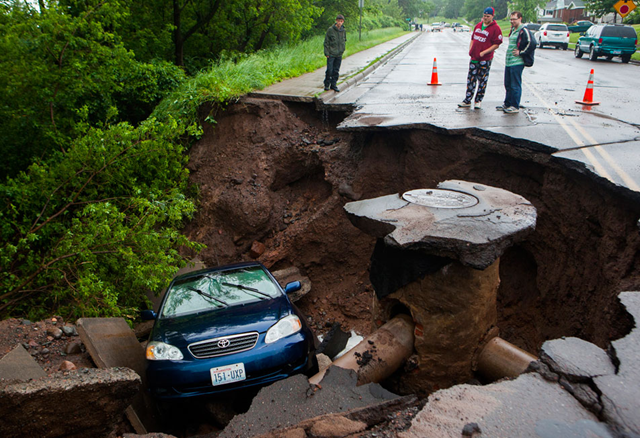
(Reached early Thursday morning) 15.8 feet – Previous flood of record from 1950 (62 years ago) Counting Catastrophes: Let the record counting begin. Weather forecasting is what you see out the windshield, current conditions are what’s in the sunroof, and climate is what’s in the rearview mirror. Meteorologists had our day Wednesday trying to keep up with frantically changing conditions in and around Duluth and the North Shore. Today, “climatologists” get to pick up the pieces and tell us what it means. All time greatest 24 hour rainfall for Duluth? Looks like it. Highest flood ever on the St. Louis River and many other North Shore streams? Likely. What just happened? In every disaster there’s usually one photo that captures the essence of the event. The photo of the scared looking seal swept away from the Lake Superior Zoo by floodwaters does the trick for me on this one. I’m tempted to call this “The Great Duluth Seal Flood of 2012.” Here’s a good preliminary account of the Duluth Mega Flood from the Duluth NWS. Three day rainfall amounts of 8 to 10 inches were common across the Minnesota Arrowhead and northwestern Wisconsin from June 17th through June 19th. The heavy rain took its toll on the road infrastructure and caused rivers and streams to flood. A cold front approached Minnesota from the High Plains on Sunday, June 17th and this front set off numerous thunderstorms through the evening. Duluth NWS received nearly an inch of rain (0.71″). The rains that fell on Sunday had inundated the soil, and created more saturated conditions than normal, which primed the Duluth area for runoff in the extreme rain event that we received. On Tuesday, June 19th another front slowly approached northeastern Minnesota. This front continually formed thunderstorms that developed over east central Minnesota and tracked northeast into the Duluth area, the north shore of Lake Superior and into northwestern Wisconsin. The official rainfall in Duluth on the 19th was 4.14 inches up until 1 am. The thunderstorms finally ended when a strong cold front moved through Wednesday afternoon. The rainfall on the 20th was 3.10″. Total rainfall for the large rainfall event was 7.24″. Numerous roads were washed out from the deluge of rain from Carlton County through the Duluth metro area and into Douglas County and Bayfield County in Wisconsin. A state of emergency was declared in Duluth, Hermantown and Superior, WI. The Fond Du Lac neighborhood of Duluth and the Thomson Township in Carlton County were evacuated due to the quickly rising St. Louis River. […]
Duluth “Mega Flood” sets new records; Quieter, drier forecast ahead
