Image of the Day: Satellite View of Receding Dead Sea, 1972, 1989, and 2011
Caption by Aries Keck and Mike Carlowicz
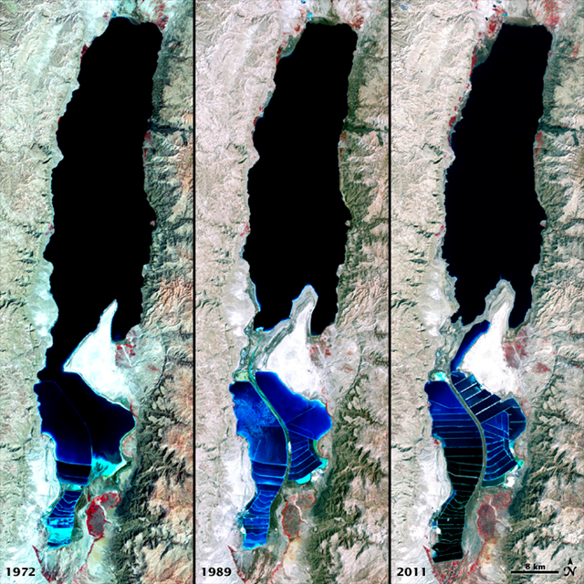
6 April 2012 The Dead Sea is so named because its high salinity discourages the growth of fish, plants, and other wildlife. This salt lake resides in a depression in the Earth’s crust, where the continents of Africa and Asia are pulling away from each other. It has pulled in visitors and industries for thousands of years. The Dead Sea is the lowest surface feature on Earth, sitting roughly 1,300 feet (400 meters) below sea level. On a hot, dry summer day, the water level can drop as much as one inch (two to three centimeters) because of evaporation. The false-color images above were captured by the Landsat 1, 4, and 7 satellites. The Multispectral Scanner System on Landsat 1 acquired the top image on September 15, 1972. The middle image was acquired on August 27, 1989, by the Thematic Mapper on Landsat 4. The third image is from the Enhanced Thematic Mapper Plus on Landsat 7 on October 11, 2011. All three images include a combination of near-infrared, red, and green wavelengths. Deep waters are blue or dark blue, while brighter blues indicate shallow waters or salt ponds (in the south). The pale pink and sand-colored regions are barren desert landscapes, while green indicates sparsely vegetated lands. Denser vegetation appears bright red. Near the center is the Lisan Peninsula, which forms a land bridge through the Dead Sea. […]