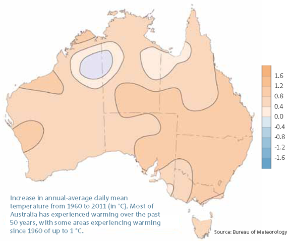
Graph of the Day: Increase in Australia Annual-Average Daily Mean Temperature, 1960-2011
Increase in annual-average daily mean temperature from 1960 to 2011 (in °C). Most of Australia has experienced warming over the past 50 years, with some areas experiencing warming since 1960 of up to 1°C. The warming trend has occurred against a backdrop of natural, year-to-year climate variability. Most notably, El Niño and La Niña events during the past century have continued to produce the hot droughts and cooler wet periods for which Australia is well known. 2010 and 2011, for example, were the coolest years recorded since 2001 due to two consecutive La Niña events. Australian annual-average daily maximum temperatures have increased by 0.75 °C since 1910, with most of the warming trend occurring since 1970. There has been an increase in the frequency of warm weather and decrease in the frequency of cold weather. Consecutive La Niña events in the past two years, however, have kept average maximum temperatures below the long-term average – by 0.24 °C in 2010 and 2011. Very few extreme hot maxima were recorded during these two years, with the exception of three heat waves in 2011 in southeast Western Australia and central South Australia in January and February, southeast Australia in August, and in northwest Western Australia in December. Australian annual-average overnight minimum temperatures have warmed more rapidly than daytime maximum temperatures. Minimum temperatures have warmed by more than 1.1 °C since 1910 – with more than 0.8 °C of that warming occurring since 1960.

There are signals popping up everywhere. The website below is another sign that weather patterns are pushing extremes. These are Amazon River Data at Iquitos Peru.
http://www.dhn.mil.pe/app/menu/servicios/rioamazonia/index.asp The swings between flood and low water are unprecedented.