Image of the Day: Satellite View of Shell Deepwater Oil Spill Off Nigeria coast, 21 December 2011
By Sara Scoville-Weaver
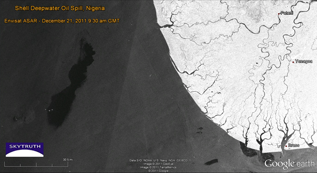
21 December 2011 Royal Dutch Shell’s Nigerian drilling operations in the highly productive Bonga Field were officially brought to a halt yesterday after “less than 40,000 barrels of oil” (1.7 million gallons) were reportedly leaked during a transfer of crude to a tanker. We’ve just processed a radar satellite image taken this morning (December 21, 2011) of the field, with the spill clearly visible. Here it is showing the slick outlined in yellow; it is about 70 km (45 miles) long, 17 km (10 miles) wide at it’s widest, and covers 923 square kilometers (356 square miles) of ocean. […] Another, much smaller oil slick appears at lower right; this looks like a bilge dump from a passing vessel, not related to the Shell spill. […]
Shelling out the Oil in Waters off Nigeria: Radar Satellite Image December 21, 2011