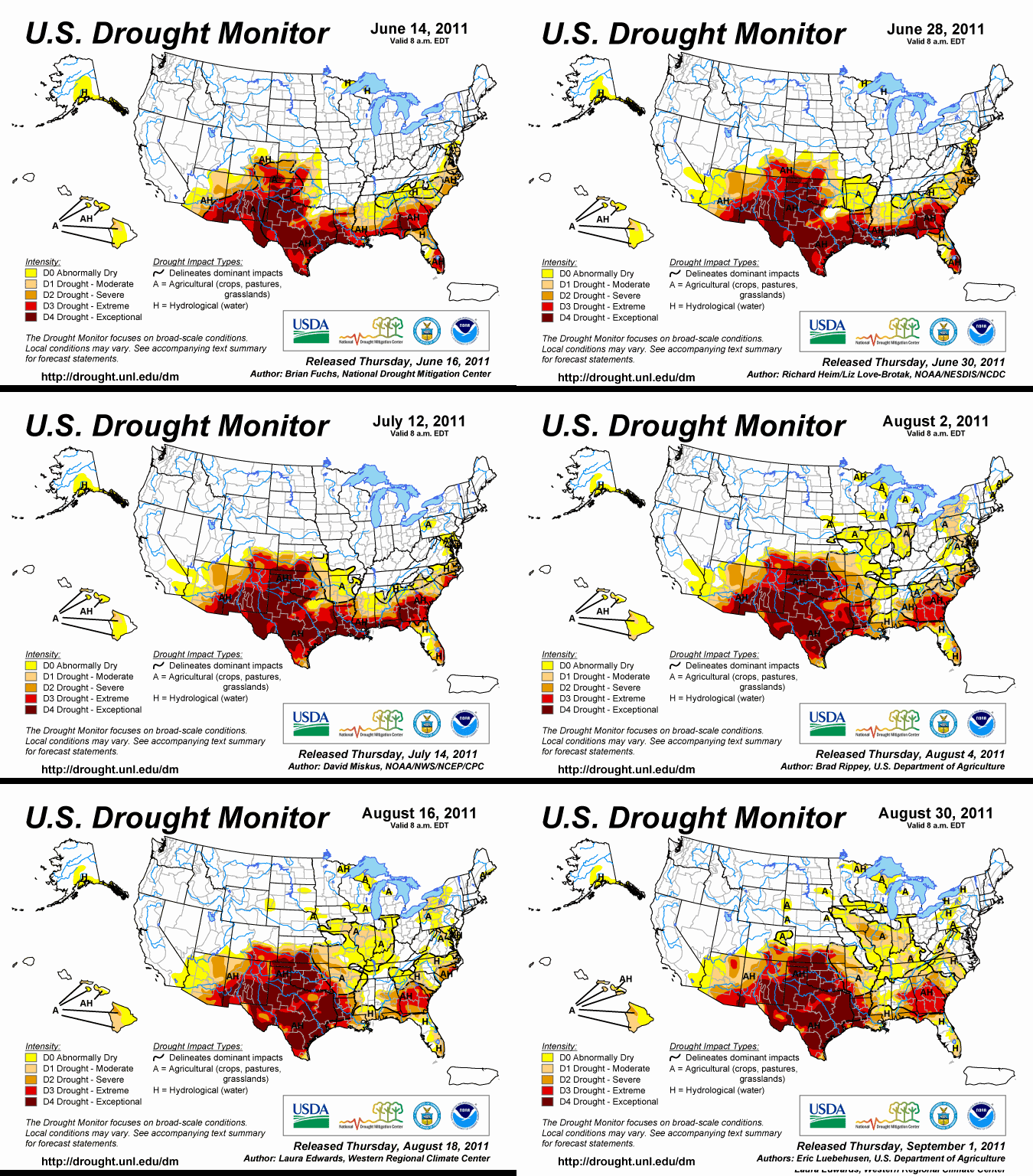
Summer 2011: Twelve weeks of exceptional drought in the U.S.
By Eric Luebehusen, U.S. Department of Agriculture
31 August 2011 Southern Plains: The beat goes on across the southern Plains. In Texas and southern Oklahoma, another week of above-normal temperatures (up to 14°F above normal, with highs eclipsing 110°F) and sunny skies further offset the benefits of early month rainfall. Consequently, drought intensified over many of the remaining D2 and D3 areas (Severe to Extreme Drought), with the vast majority of Texas and Oklahoma under Exceptional Drought (D4). As of August 29, pasture and range condition was rated 98 and 92 percent poor to very poor in Texas and Oklahoma, respectively. Further illustrating the heat and drought’s devastating impacts, cotton – a crop that generally thrives in hot, dry weather – was rated 60 percent poor to very poor in Texas and an astounding 92 percent poor to very poor in Oklahoma. 180-day rainfall deficits exceeded 14 inches in southwestern Oklahoma and north-central Texas, and were locally in excess of 20 inches near Houston. Farther east, scattered, mostly light showers offered little if any relief from Severe (D2) to Exceptional (D4) Drought from eastern Oklahoma into eastern and far southern Texas. Four Corners Region: Drought relief over northeastern portions of the region contrasted with an increase in drought designation in southwestern locales. Beneficial showers (1 to 2 inches) further improved soil moisture in northern New Mexico as well as southern and eastern Colorado; consequently, the coverage of Moderate (D1) to Extreme (D3) Drought was reduced in these areas to reflect the most current Standardized Precipitation Indices (3, 6, 9, and 12 month). The coverage of Colorado’s Exceptional Drought (D4) was virtually unchanged, with small modifications made to account for the updated VegDri Index as well as the most recent precipitation data. Environs within the core D4 area are still below 25 percent of normal precipitation over the past 180 days, although additional local analysis and input may lead to changes in drought designation over the upcoming weeks. Abnormal Dryness (D0) on the High Plains of Colorado was expanded slightly northeastward due to a lack of rain over the past 30 to 60 days, a low 3-month Standardized Precipitation Index, declining soil moisture, and increasingly poor VegDri Index. In southern and western Arizona, expansion of Moderate (D1) to Extreme (D3) drought was a reflection of a drier-than-normal monsoon to date (less than 50 percent of normal rainfall over the past 90 days). Temperatures over southern and western Arizona averaged 9 to 13°F above normal during the past week, exacerbating the impacts of the drier-than-normal weather. Furthermore, Standardized Precipitation Indices on numerous timescales (3 to 12 months) indicated developing or expanding drought in western Arizona. Dryness has also increased in central and southeastern portions of Nevada as well as much of the Northwest, and these areas will need to be monitored closely over the upcoming weeks.
National Drought Summary — August 30, 2011
