Analysis: When will the terrible Texas drought end?
By Eric Berger
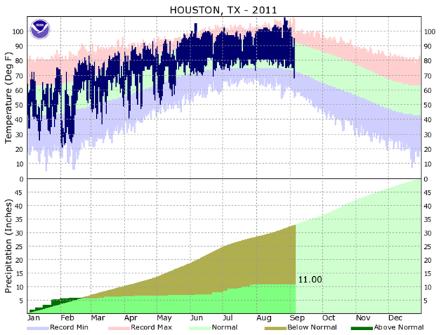
7 September 2011 A couple of weeks ago I reported on the possibility of the current drought plaguing Texas extending into next summer. This is because of the 50 percent probability that La Niña will redevelop after this fall, bringing another dry winter to the state of Texas. With this in mind, now that we’re into fall, I asked ImpactWeather‘s Fred Schmude for his thoughts on the drought persisting for awhile. He responded with a long, and thoughtful answer, which I’ve attached below as a guest blog entry. It’s worth reading in its depressing entirety. A question many people are raising right now is when will the current intense drought end? Before we answer that question we really need to figure out what caused the current dry spell and see if there are any changes forecast for the near or distant future. The drought really intensified last winter thanks in large part to a very strong La Niña over the eastern Tropical Pacific. La Niñas typically result in a weaker than normal sub tropical storm track limiting the amount of rain producing weather disturbances that affect the Texas area during a normal winter. For this year that phenomena started in February and intensified during March and April with very few rain producing weather systems. By the later part of spring and early summer the La Niña phenomena weakened and became a non player, however the very dry soil over the Texas region intensified the drought and allowed a semi-permanent upper-level high pressure to build over the area keeping most of the rain bearing tropical disturbances either south or east of the Texas Gulf Coast. As a result, most of Texas was left high and dry resulting in the current 20-25 inch rain deficit we are currently experiencing in the Houston area and the increased fire danger as wildfires quickly spread across central and east Texas. Unfortunately the main players that caused the very intense drought last winter are coming back this winter in the form of another potential La Niña condition. We currently are favoring a redeveloping moderate to strong La Niña this winter based largely on another weather phenomena called the Pacific Decadal Oscillation, or PDO. The PDO is a large scale weather cycle over the northern Pacific Ocean which demonstrates alternating periods of cold and warm cycles, which can typically last 10 to 20 years. When the PDO is in its cold phase, La Niñas typically are more frequent and intense while the reverse is true during the warm phase of the PDO. For this year the PDO has shifted toward the negative phase, which is signaling a redeveloping La Niña later this fall as colder than normal water over the eastern Pacific Ocean is funneled southward into the eastern Tropical Pacific. As a result, we should see the current drought persist through next spring over most of Texas, including the greater Houston area as La Niña intensifies. Yes, Texas will likely see some welcomed wet periods at times during the fall and early winter as the polar storm track occasionally shifts south bringing quick bursts of precipitation associated with cold fronts and other fast moving disturbances; however, below to well-below-normal precipitation will likely by the dominant weather trend over most of the state though next May. We can always hope for some type of a weak tropical system during the latter half of September into October, but even that scenario is looking less likely with time. By the way our three driest years on record in the Houston area occurred in 1917 (17.66”), 1988 (22.93”) and 1901 (27.09”). In a normal year the Houston area will typically receive around 45.00 to 50.00” of rainfall, so you can see in 1917 we had a little more than third of the normal rainfall while in 1988 we had roughly half. This year we have currently tallied 11.00” for the year, while we should be at 32.58”, meaning so far this year we have received only about a third of our normal rainfall and are on a pace to tie or unfortunately surpass the all time 1917 record. […]

Analysis from an observer:
Never.
The southwestern states are quite literally "toast". Climate change models predict increasing dry conditions, with increasing temperatures for at least a thousand years or more.
Water supplies will continue to dry up, including aquifers, which can take decades to recharge. But this is under normal conditions, which will not happen again for any significant periods of time.
To put this into context, a decade from now the temperatures will be higher, water supplies critical, fires even worse, with a mass refugee problem throughout the southern states.
There is no solution to this either.
The refusal to acknowledge the "new normals" of higher temps, drought, flooding in other regions, rising sea levels and other effects has led the majority of the developed world (where intelligence is alleged to reign) into cognitive dissonance, a refusal to accept the truth and the responsibility of what is causing this.
This has committed the human race and the rest of the biosphere to hundreds of years of suffering and decline.
This is why deniers, especially in America are actively committing crimes against humanity through their constant refusal to accept the facts.
The evidence of their denial and the real world results is happening right now, as it all burns to the ground (ie., Texas), an in-our-face slap to human stupidity and belligerence that "it can't be us".
The longer these ill-informed fools are allowed to keep this country doing the wrong thing, the worse it's going to be for everyone.