Storm warnings: Extreme weather is a product of climate change
More violent and frequent storms, once merely a prediction of climate models, are now a matter of observation. This is the first of a three-part series 
By John Carey
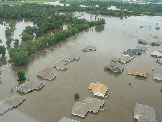
28 June 2011 Editor’s note: This article is the first of a three-part series by John Carey. Part 2, “Global Warming and the Science of Extreme Weather,” was posted on June 29. Part 3, “Our Extreme Future: Predicting and Coping with the Effects of a Changing Climate”, was posted on June 30. In North Dakota the waters kept rising. Swollen by more than a month of record rains in Saskatchewan, the Souris River topped its all time record high, set back in 1881. The floodwaters poured into Minot, North Dakota’s fourth-largest city, and spread across thousands of acres of farms and forests. More than 12,000 people were forced to evacuate. Many lost their homes to the floodwaters. Yet the disaster unfolding in North Dakota might be bringing even bigger headlines if such extreme events hadn’t suddenly seemed more common. In this year alone massive blizzards have struck the U.S. Northeast, tornadoes have ripped through the nation, mighty rivers like the Mississippi and Missouri have flowed over their banks, and floodwaters have covered huge swaths of Australia as well as displaced more than five million people in China and devastated Colombia. And this year’s natural disasters follow on the heels of a staggering litany of extreme weather in 2010, from record floods in Nashville, Tenn., and Pakistan, to Russia’s crippling heat wave. These patterns have caught the attention of scientists at the National Climatic Data Center in Asheville, N.C., part of the National Oceanic and Atmospheric Administration (NOAA). They’ve been following the recent deluges’ stunning radar pictures and growing rainfall totals with concern and intense interest. Normally, floods of the magnitude now being seen in North Dakota and elsewhere around the world are expected to happen only once in 100 years. But one of the predictions of climate change models is that extreme weather—floods, heat waves, droughts, even blizzards—will become far more common. “Big rain events and higher overnight lows are two things we would expect with [a] warming world,” says Deke Arndt, chief of the center’s Climate Monitoring Branch. Arndt’s group had already documented a stunning rise in overnight low temperatures across the U.S. So are the floods and spate of other recent extreme events also examples of predictions turned into cold, hard reality? Increasingly, the answer is yes. Scientists used to say, cautiously, that extreme weather events were “consistent” with the predictions of climate change. No more. “Now we can make the statement that particular events would not have happened the same way without global warming,” says Kevin Trenberth, head of climate analysis at the National Center for Atmospheric Research (NCAR) in Boulder, Colo. That’s a profound change—the difference between predicting something and actually seeing it happen. The reason is simple: The signal of climate change is emerging from the “noise”—the huge amount of natural variability in weather. […]
Storm Warnings: Extreme Weather Is a Product of Climate Change