U.S.-Japan joint survey reveals high radiation beyond evacuation zone
BY HISAE SATO STAFF WRITER
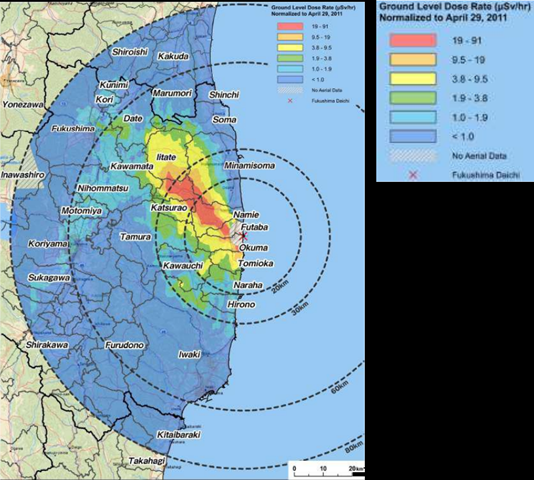
8 May 2011 The first map of ground surface contamination within 80 kilometers of the crippled Fukushima No. 1 nuclear power plant shows radiation levels higher in some municipalities than those in the mandatory relocation zone around the Chernobyl plant. The map, released May 6, was compiled from data from a joint aircraft survey undertaken by the Ministry of Education, Culture, Sports, Science and Technology and the U.S. Department of Energy. It showed that a belt of contamination, with 3 million to 14.7 million becquerels of cesium-137 per square meter, spread to the northwest of the nuclear plant. After the 1986 Chernobyl disaster, those living in areas with more than 555,000 becquerels of cesium-137 per square meter were forced to relocate. However, the latest map shows that accumulated radioactivity exceeded this level at some locations outside the official evacuation zones, including the village of Iitate and the town of Namie. “I am surprised by the extent of the contamination and the vast area it covers,” said Tetsuji Imanaka, assistant professor of nuclear engineering at the Kyoto University Research Reactor Institute. “This (map) will be useful in planning evacuation zones as well as the decontamination of roads and public facilities. …
U.S.-Japan joint survey reveals high radiation beyond evacuation zone