Image of the Day: Satellite View of Lingering Floods in Pakistan, January 2011
Caption by Michon Scott
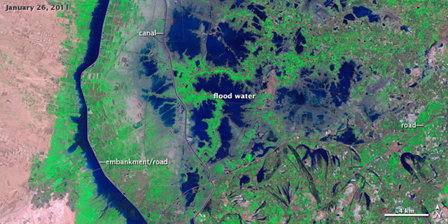
12 April 2011 Monsoon rains fall on Pakistan every summer, but the summer of 2010 was extraordinary. A combination of factors, including La Niña and a strange jet stream pattern, caused devastating floods. The Indus River rapidly rose, and a dam failure in Sindh Province sent part of the river down an alternate channel. The resulting floodwater lake lingered for months, leaving crops, roads, airports, even entire communities underwater. The town of Khairpur Nathan Shah was one of many communities affected by the floodwater lake. Normally surrounded by croplands and irrigation infrastructure, the town was instead surrounded by water for months. The Landsat 5 satellite captured this image of the area on January 26, 2011. In this false-color image, water appears blue, vegetation appears bright green, and bare land ranges in color from in pink-beige to brick. … By January 26, more areas have emerged from the water, but the region is by no means back to normal. A complex network of irrigation infrastructure also reappears as the landscape dries out. Once flood water pushed over riverbanks, manmade canals and embankments proved all too effective in holding that water in the wrong places. A new article, Heavy Rains and Dry Lands Don’t Mix: Reflections on the 2010 Pakistan Flood, examines the 2010 monsoon and its aftermath. Here is an excerpt. …