Indonesian Borneo and Sumatra lose 9 percent of forest cover in 8 years
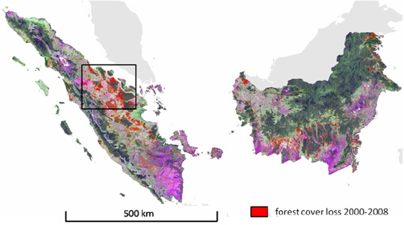
February 25, 2011 (mongabay.com) – Kalimantan and Sumatra lost 5.4 million hectares, or 9.2 percent, of their forest cover between 2000/2001 and 2007/2008, reveals a new satellite-based assessment of Indonesian forest cover. The research, led by Mark Broich of South Dakota State University, found that more than 20 percent of forest clearing occurred in areas where conversion was either restricted or prohibited, indicating that during the period, the Indonesian government failed to enforce its forestry laws. “Our analysis showed that the majority of all mapped forest cover loss (79.9%) occurred in land allocation zones that permit permanent or temporary clearing, while 20.1% occurred where clearing is either prohibited or restricted,” the authors write. Under Indonesian law, clearing of conservation forest, protection forest, and limited production forest is illegal. Forest loss was higher in Sumatra, which saw large areas of forest converted for pulp and paper plantations and oil palm estates. Both Sumatra and Kalimantan suffered from large-scale fires set for land-clearing purposes. Overall, deforestation peaked in 2006, when forest loss topped 900,000 hectares. Riau and Central Kalimantan provinces accounted for nearly half of the total forest cover loss, according to the analysis. …
Indonesian Borneo and Sumatra lose 9% of forest cover in 8 years