Graph of the Day: Percent of Normal Precipitation in Brazil, Summer 2010
By Nick Sundt
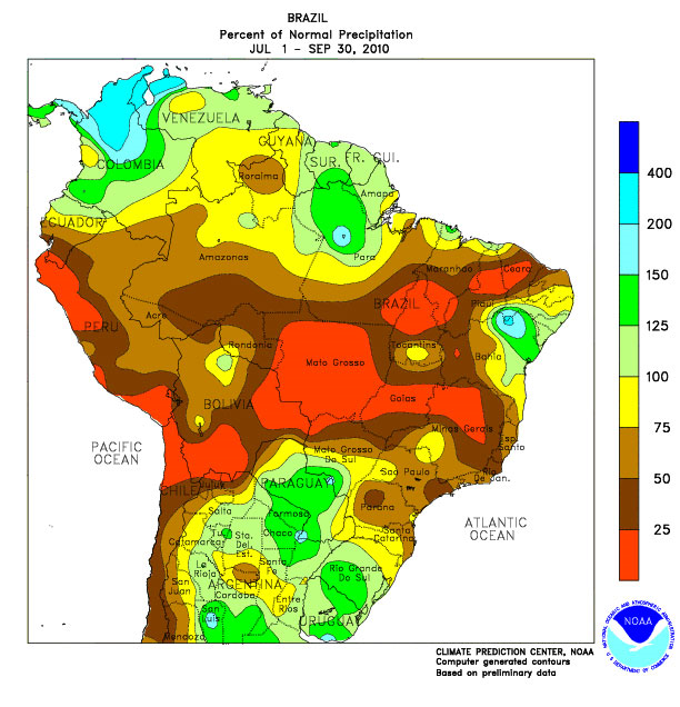
11/23/2010 The Amazon region is experiencing the third extreme drought in a dozen years — and it may turn out to be the worst on record. The droughts coupled with recent research findings, suggest that rising atmospheric concentrations of greenhouse gases will rapidly increase the frequency and severity of droughts in the region. The implications for people, biodiversity and climate are ominous. … This graph illustrates that most of the Amazon region received less than 75% of normal rainfall between 1 July and 30 September. Large areas have received far less precipitation, in many cases less than 25% of normal. In a press release on 22 October 2010 (Seca pode bater recorde na Amazônia / Drought may hit record in the Amazon), Brazil’s Amazon Environmental Research Institute (Instituto de Pesquisa Ambiental da Amazônia or IPAM) said:The drought of 2010 still hasn’t ended in the Amazon and could surpass that of 2005 as the region’s worst during the past four decades. In the Western Amazon, the Solimões River reached its lowest level in recorded history. In Manaus, the level of the Rio Negro (Black River) is approaching that of 1963 – the lowest in a century. Even if this doesn’t occur, the forest will have already experienced three extreme dry spells in just 12 years, two of which occurred during the past five years: 1998, 2005 and 2010. And this is not including the drought of 2007, which affected only the Southeastern Amazon and left 10 thousand sq. km. of forest scorched in the region…`The Amazon that had wet seasons so well-defined that you could set your calendar to them – that Amazon is gone,‘ says ecologist Daniel Nepstad of IPAM. …
Among the consequences of the drought are extremely low flows on many of the region’s rivers. On 24 October 2010, the Rio Negro, a major tributary of the Amazon, reached an all time low of 13.63 m at Manaus, edging out 1963 when water levels reached 13.64 m (Monitoramento Hidrologico: 2010, Boletim no 33 – 29/10/2010, by the Companhia de Pesquisa de Recursos Minerais or CPRM). In contrast, just last year, the river saw an all time record high of 29.77 m as the region experienced devastating floods. (Relatorio da Cheia 2009 [PDF] [2010], by CPRM). See photos of the flood [PDF]. Records for the Rio Negro extend back 107 years. See also Flooding Near Manaus, Brazil, NASA Earth Observatory, 19 August 2010. Writing for the New York Times upon his return from Iquitos, Peru, Nigel Pitman reports that “people were deeply upset by the lack of rain.” He explains: “Long dry spells like these in Amazonia wither crops and worsen air pollution and cut off whole towns from the rest of the world, when the arm of the river they’re on turns to mud. They also destroy forests” (Drought in the Amazon, Up Close and Personal, 12 November 2010). Satellite imagery on 19 August showed a pall of smoke concentrated over Bolivia (see Fires in South America, NASA Earth Observatory, 8 September 2010), where drought conditions allowed fires to burn out of control, prompting the Bolivian government in mid-August to declare a state of emergency. …
Another Extreme Drought Hits the Amazon and Raises Climate Change Concerns
Ah, 1998, 2005 and 2010: the three warmest years in recorded history and also three severe droughts in the Amazon. Remind me again why warming is bad news?