Receding glaciers on Mount Rainier threaten park’s major roadways
By Jeffrey P. Mayor, The Tacoma News Tribune
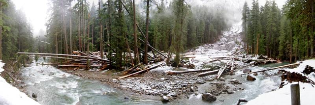
12/06/1012:01 pm The greatest threat to the busiest road in Mount Rainier National Park is the mountain itself. Receding glaciers, loose rocks and boulders, glacial outbursts and debris flows could combine to cut off Nisqually-Paradise Road. Half the 1.2 million people who typically visit the park each year travel that roadway. Yet the threat is not limited to the 18-mile road. Nearly every major roadway in the park – including Westside Road, Stevens Canyon Road, state Route 123, state Route 410 and Carbon River Road – is threatened. Portions of the Carbon River and Westside roads have been closed because of flooding. Stevens Canyon and state Route 123 are susceptible to landslides. State Route 410 could be flooded should the White River jump its banks. “It’s almost historically unprecedented the conditions Mount Rainier (National Park) has to manage in terms of access,” said Paul Kennard, the park’s geomorphologist. … To protect Mount Rainier’s main thoroughfare, park geologists this summer identified six locations along the road they believe are the most threatened. The study – prompted by the historic November 2006 flood and additional floods in 2008 and 2009 – comes as the park develops a proposal for a $30 million, three-phase project to repave Nisqually-Paradise Road. … Still fresh in the minds of many is the park’s six-month closure after the November 2006 flood. The unprecedented flood caused $36 million in damage, including every major road in the park. … Carolyn Driedger is a hydrologist with the U.S. Geological Survey and an expert on the volcanic and glacial nature of Mount Rainier. She has been studying the mountain since 1979. She said while these changes are the norm at a location such as Mount Rainier, their pace has quickened. “We recognize the Earth is certainly not static, it’s ever-changing,” she said. “The mountain you see today is a little different than the mountain your grandparents saw and what your grandchildren will see. “But as we seek to understand Earth systems, how climate changes geological and hydrological processes, (the access issue) comes into play,” Driedger said. Driedger was referring to the cascading effect of climate change that starts with shrinking glaciers and ends with destructive torrents of debris racing downstream toward key points throughout the park. It all begins at the top of the mountain. The 26 major glaciers and unnamed snowfields cover about 36 square miles with a volume of about one cubic mile, making it the most glaciated mountain in the lower 48 states. That ice blanket is shrinking. Research by Portland State University doctoral student Thomas Nylen shows that between 1913-1994 the mountain lost 25 percent of its glacial volume. A study by Jon Reidel, geologist at North Cascades National Parks, indicates the rate of loss from 2003-2009 was 4.2 times faster than the rate through 1994 and there has been another 10 to 18 percent decline in volume. “That is a shocking amount of lost water in a very short period of time,” Reidel said. “As a glacier retreats, it exposes a huge amount of material that can be washed downstream,” Kennard said. Rocks and sediment created by the grinding effect of glaciers are suddenly exposed to the elements, needing only water to begin moving down the mountain. …
Receding glaciers on Mount Rainier threaten park’s major roadways