Photo gallery: 50 Doomiest Photos of 2010
Desdemona’s quest against delusional hope won’t be won by presenting the cold, hard numbers alone. The right hemisphere of the brain must be engaged as well, and to this end Desdemona goes to great lengths to find dramatic images to enliven the numbers. Here are the most doom-laden photos of 2010, chosen by scale, impact, what’s at stake, or the particular that embodies the general. The three most frequently represented events are the Pakistan flood (seven photos), the BP Deepwater Horizon oil spill (ten), and desertification/freshwater depletion (nine). News coverage of the Pakistan flood fell off dramatically in the U.S.; CNN called the Haiti earthquake “the worst big story of the year,” even though the U.N. has stated that Pakistan flood damage exceeds that of the 2004 tsunami, the 2005 Kashmir earthquake, and the 2010 Haiti earthquake combined. Desdemona imagines that the U.S. public can’t be allowed to realize that the U.S.S. Pakistan, from which the U.S. launches much of its land war in Asia, is hulled and sinking. There was precious little coverage anywhere of the record flooding in central and west Africa, in spite of a UN bulletin calling it the “largest number of people affected and dying from flooding” on record. It was very hard to find any photos of these floods. This strange lacuna led to possibly the best reader comment of 2010:
How come I can’t find any new information on this crisis? 10 MILLION people facing starvation and the most recent news article is from Al Jazeera! This is the most up-to-date thing I can find, and it’s dated September! I am searching November 23, 2010! What is going on?
If you suspected that 2010 was a big year for extreme weather disasters, you were probably right: both the World Meteorological Organization and the global re-insurance giant Munich Re agree. The money quote for weather chaos came from Craig Fugate, who heads the U.S. Federal Emergency Management Agency: “The term ‘100-year event’ really lost its meaning this year.” By one estimate, the Russia heat wave was on the order of a 100,000-year event. People who deny the rapid change in Earth’s climate had more to deny this year than ever before.
- 2013 doomiest graphs, images, and stories
- 2012 doomiest graphs, images, and stories
- 2011 doomiest graphs, images, and stories
- 2010 doomiest graphs, images, and stories
A wildfire sweeps through Bitterroot National Forest in Montana. Image courtesy of John McColgan, USDA Forest Service.
Study: Climate change means greater risk of catastrophic wildfire — 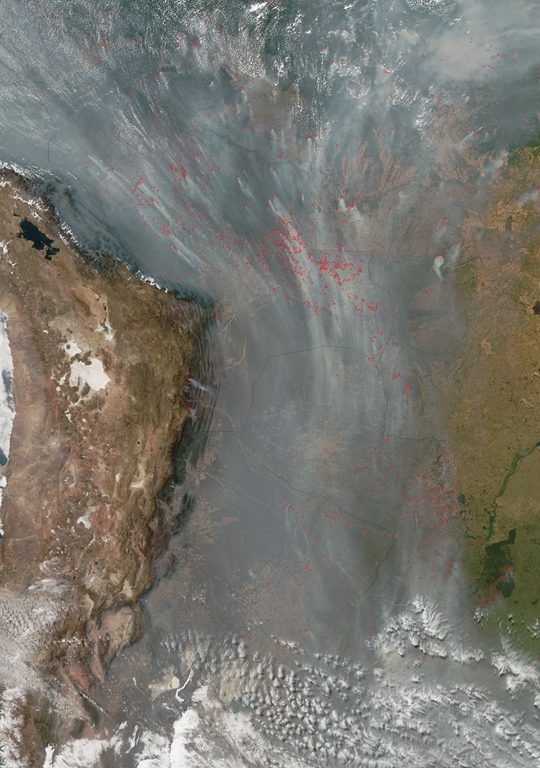
Fires and smoke in South America, September 1, 2010. Jeff Schmaltz, MODIS Land Rapid Response Team, NASA GSFC The Moderate Resolution Imaging Spectroradiometer (MODIS) on NASA’s Aqua satellite detected 148,946 fires in this image on August 23, 2010. The fires are outlined in red. Most of the fires are concentrated in Bolivia, where the governments of two states had declared a state of emergency because of widespread fires three days earlier. Scores of fires also burn in Brazil, Paraguay, and Argentina. … Most of these fires were probably set deliberately to clear land for crops or pasture.
Image of the Day: South America Forest Fires Viewed from Orbit, 1 September 2010 — 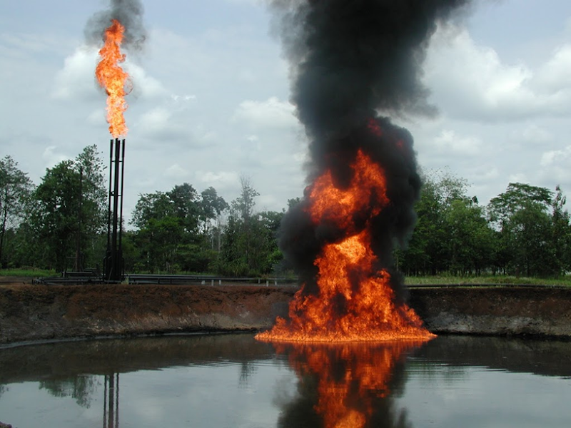
A pool of crude oil and toxic drilling waste burns at an abandoned Texaco-Chevron oil production facility in Cofan territory. Shushufindi, Ecuador. ©Amazon Watch
Image of the Day: Abandoned Oil Facility in the Ecuadorean Amazon — 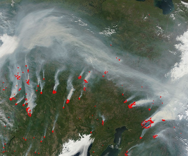
Fires and smoke in eastern Siberia, 30 July 2010, viewed from the Terra satellite.
Image of the Day: Russia Forest Fires and Smoke Viewed from Orbit, 30 July 2010 — ![[image[35].png]](http://lh4.ggpht.com/_pQyvcBbJ0Fs/TF4YHqBfO1I/AAAAAAAACSU/diewqTHapkU/s1600/image%5B35%5D.png)
St. Basil’s Cathedral, left, and the Kremlin, right, are seen as tourists walk through thick smog at Red Square in Moscow, Russia, Friday, Aug. 6, 2010. AP Photo / Mikhail Metzel Several thousand Muscovites are thought to have died in July alone from this year’s unprecedented heatwave.
Heat probably killed thousands in Moscow — 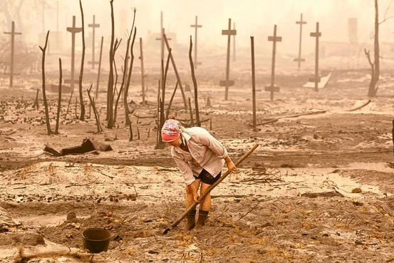
A woman digs out potatoes in her former garden, ravaged by wildfires that also burned her house, in Verkhnyaya Vereya village, Russia, 3 August 2010. Source: European Pressphoto Agency
2010 to be among three warmest years, U.N. says — 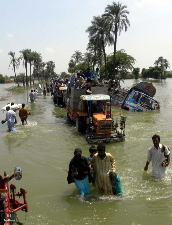
People flee the flooded areas from Basera, near Muzaffargarh, in Punjab Province, Pakistan on 21 August 2010. Pakistan reassured international donors that aid for flood victims would not fall into Taliban hands, as the UN said funds were only trickling in. More than 1,500 people across Pakistan have been killed and hundreds of thousands stranded due to flash floods triggered by the ongoing spell of monsoon rains. EPA / MATIULLAH ACHAKZAI
Photo gallery: Pakistan floods — 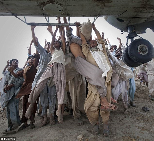
Marooned flood victims looking to escape grab the side bars of a hovering Army helicopter which arrived to distribute food supplies. Reuters via dailymail.co.uk
Environmental apocalypse: Fire and flood — 
Desperate: Refugees fight to get food donated by a local charity in the village of Karamdad Qureshi in Punjab province, 22 August 2010. Some 20 million people have been affected by the worst flooding in Pakistan’s history. Reuters
Desperate refugees fight over food as UN says eight million flood-stricken Pakistanis are in ‘urgent need’ of food — 
An aerial view shows a flooded mosque in a village in Sujawal, about 150 km (93 mi) from Karachi in Pakistan’s Sindh province, August 29, 2010. REUTERS / Akhtar Soomro
Pakistan floods continue to drive tens of thousands of people from their homes every day — 
An area of land surrounded by flood water is pictured from a rescue helicopter operated by the Pakistani army near Dadu, Sindh province, Pakistan, 2010. Photo: AFP
Pakistan: Highway to nowhere — 
Flood disaster: Buildings sit among floodwaters in Sindh province, Pakistan, August 2010. Getty Images / Paula Bronstein / abc.net.au
Pakistan flood crisis blamed partly on deforestation — 
The Advanced Spaceborne Thermal Emission and Reflection Radiometer (ASTER) instrument on NASA’s Terra spacecraft captured this cloud-free image over the city of Sukkur, Pakistan, on Aug. 18, 2010. NASA / GSFC / METI / ERSDAC / JAROS, and U.S. / Japan ASTER Science Team
Image of the Day: Indus River Flooding Viewed from Orbit, 18 August 2010 — 
Aerial view shows a mosque in the flooded southern Thai city of Hat Yai, November 2, 2010. Thailand battled on November 2 to rescue thousands of people trapped in their homes after flash floods — several metres deep in places — swept through a southern city, cutting power and communications. Rising waters began to inundate Hat Yai, a city of more than 150,000 in Songkhla province, late on November 2 after days of heavy downpours. Photo: REUTERS via telegraph.co.uk
Flash floods strand thousands in major Thai city – Six million affected across Thailand — 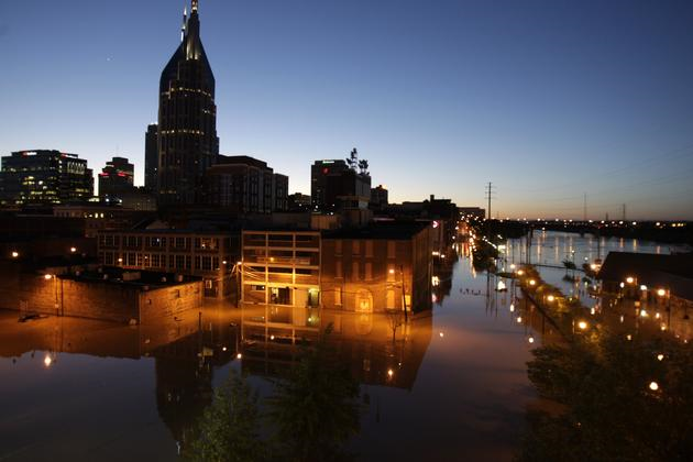
Floodwater from the Cumberland River creeps into downtown Nashville, Tenn., Monday, May 3, 2010. Heavy weekend rain caused the Cumberland River, which winds through Nashville, to overflow its banks flooding part of downtown and other areas around the city. AP Photo / Jeff Roberson
Photo gallery: Flooding in Nashville — 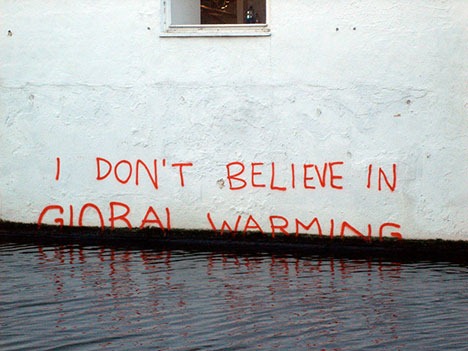
I Don’t Believe in Global Warming, by Banksy, December 20, 2009. Photo: TheMammal via flickr
How global climate change may affect violence — 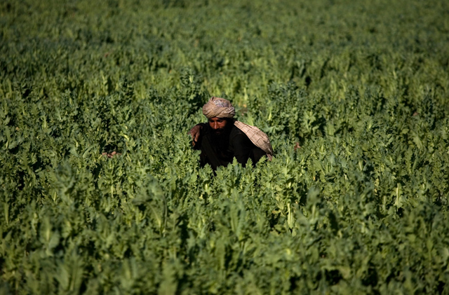
In this photo taken on Friday, March 19, 2010, a farmer works in a poppy field in Marjah, Afghanistan. When U.S., Afghan and NATO forces stormed Marjah in February, they were instructed to seize large opium stashes but leave farmers’ poppy fields alone. AP Photo / Dusan Vranic
Image of the Day: Poppy Field in Marjah, Afghanistan — 
Burning oil on the surface of the Gulf of Mexico, 17 June 2010. James Duncan Davidson via flickr
Aerial views of the Gulf oil spill: The photography of James Duncan Davidson — 
Envisat / ASAR radar satellite image (black-and-white inset) taken June 22, 2010. Color backdrop is June 22 MODIS / Aqua image. ASAR data courtesy of CSTARS. Analysis by SkyTruth
Image of the Day: BP / Gulf Oil Spill – ASAR Image June 22, 2010 — 
A bird flies above oil lapping the shore of East Grand Terre Island on the Louisiana coast. Picture: AP via telegraph.co.uk
Oiled birds everywhere, but little rescue crews can do — 
A close up of one of the corals impacted by the BP Deepwater Horizon oil spill. A small amount of apparently living tissue on the tips of some branches is orange. Most of the skeleton is bare or covered by brown flocculent material. Lophelia II 2010, NOAA OER and BOEMRE
Dead, dying coral found near BP spill called ‘smoking gun’ — ‘We have never seen anything like this’ — 
Controlled burns are conducted in the Gulf of Mexico in an effort to burn off some of the oil in the water, 19 May 2010. John Kepsimelis / U.S. Coast Guard via Reuters
Image of the Day: Controlled burning of Gulf oil spill — 
Handout photo provided by Greenpeace on April 30, 2010 shows birds flying over the oil on the waters near Breton Sound Island, southern most tip of the Chandeleur Islands in the Gulf of Mexico, south of Louisiana, where oil leaking from the Deepwater Horizon wellhead continued to spread. Photograph by: Sean Gardner, AFP / Getty Images
Gulf oil spill a threat to Arctic birds — 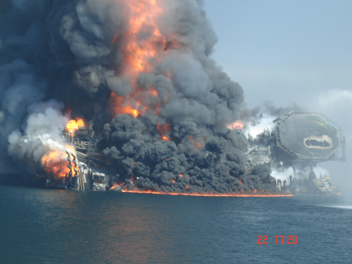
The BP Deepwater Horizon oil platform moments before sinking in the Gulf of Mexico. Gulf Oil Spill Picture Gallery: The Last Four Minutes of the Deepwater Horizon. via industry.bnet.com
Crew argued over drilling plan before rig explosion — 
Dark clouds of smoke and fire emerge as oil burns during a controlled fire in the Gulf of Mexico, May 6, 2010. The U.S. Coast Guard working in partnership with BP PLC, local residents, and other federal agencies conducted the “in situ burn” to aid in preventing the spread of oil. REUTERS / Mass Communication Specialist 2nd Class Justin Stumberg-US Navy
BP says will deploy small dome in next few days — ‘We don’t have a definitive date’ — 
A pair of bottle-nose dolphins swim under the oily water of Chandeleur Sound in Louisiana, 6 May 2010. Alex Brandon / AP
Dead dolphins wash up on Ship Island — 
Burning oil sends up a massive plume of black smoke a few miles from the site of the rig explosion in the Gulf of Mexico Thursday, 6 May 2010. JOHN MCCUSKER / THE TIMES-PICAYUNE nola.com
What next? After failure, BP mulls gusher options — 
Refugees have left their farmlands and are living in tents in Ar Raqqah, Syria, because of the extended drought. Julien Goldstein for The New York Times
Years of drought and mismanagement hit Syria water supply, cause largest internal migration in country’s history — 
A baby baboon clings to its mother, with the receding shore of Lake Nakuru in Kenya in the background, on October 7, 2009. AP Photo / Khalil Senosi
Image of the Day: The Receding Shore of Lake Nakuru — 
Stefano De Luigi, a VII Network for Le Monde Magazine photographer based in Italy, won the second prize in the Contemporary Issues Singles category of the World Press Photo Contest 2010 for this photograph of a giraffe killed by drought in northeast Kenya. (REUTERS/Stefano De Luigi/VII Network/Le Monde Magazine)
Image of the Day: Drought in Kenya — 
A farmer takes water from a dried-up pond to water his vegetables in China’s Jiangxi province. Population growth and desire for western lifestyles put immense demands on water in countries such as China and India. Photograph: Reuters
Peak Water: ‘The iconic rivers of our imagination are drying up’ — 
Thousands of zebra and other herbivores died of starvation, disease and predation, and an untold more animals abandoned the traditional dry-season refuge in search of vegetation. Michael Burnham
As weather tracks with climate scientists’ grim forecasts, Kenya is awash in misery — 
A rare herd of desert elephants in Mali ravaged by one of the worst droughts in living memory, which has left water sources at lowest level in the past quarter of a century. 350 to 450 elephants of Gourma, the northernmost herds still alive in Africa, were forced to trek extreme distances across the fringes of the Sahara to find scarce water. Juveniles’ trunks are not long enough to reach deep into wells. Lake Banzena is the lowest it has been since 1983 when it dried completely. Photo by Jake Wall
Amid historic drought, Red Cross buys starving cattle to feed Malians — ‘Dead animals litter the ground’ — 
In this May 24, 2010 photo released by National Park Ujung Kulon, bones of a Javan rhino scatter in the national park in Ujung Kulon, about 160 kilometers (100 miles) southwest of Jakarta, the capital of Indonesia. The discovery of three dead Javan rhinos has intensified efforts to save one of the world’s most endangered mammals from extinction, with an electric fence being built Monday, June 21, 2010 around the new sanctuary and breeding ground. AP Photo / National Park Ujung Kulon
Officials scramble to save endangered Javan rhinos — 
A solitary man and an ox cart travel across an area where locals went fishing less than a year ago in Damoguzhen County, Yunnan. ‘The old folk say it has never dried up in their lifetimes.’ Photograph: Jonathan Watts / Guardian
Photo gallery: Historic drought in southwest China and the Mekong basin —
Lake Nakuru National Park, Kenya: One of thousands of dead flamingos on the dry lake bed. The number of flamingoes living on the lake has declined dramatically, a number of factors have been blamed including the receding waters of the lake, and pollution. Kirsty Wigglesworth / AP
Image of the Day: Wasting of Lake Nakuru, Kenya — 
Wild Zebras stand in a container to be loaded onto waiting trucks by Kenya Wildlife Service officers, KWS, at Soysambu conservancy in Nakuru, Kenya for their translocation to Amboseli national park on February 10, 2010. Kenyan game rangers began rounding up thousands of zebras to be moved to a reserve where starving lions have been attacking livestock. KWS aims to move some 7,000 animals in all, 4,000 zebra and 3,000 wildebeest. TONY KARUMBA / AFP / Getty Images
Image of the Day: Translocation of Wild Zebras — 
Lake Mead from Hoover Dam, April 2010. inkstain.net
Lake Mead hits record low level — 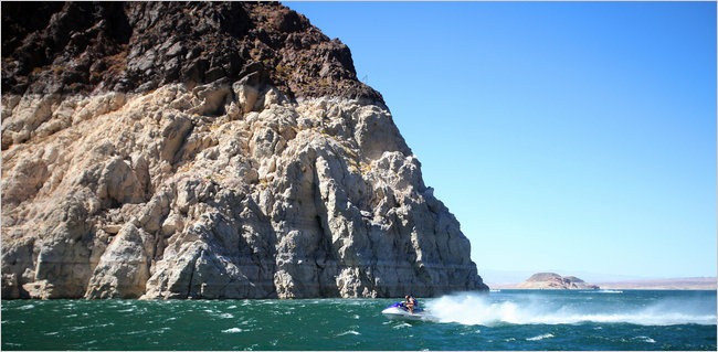 Alkaline bathtub rings reflect the falling water level on Lake Mead’s walls, September 2010. Jim Wilson / The New York Times Worst drought in recorded history to trigger shortage plan in Southwest US —
On October 9, 2010, the Advanced Land Imager (ALI) on NASA’s Earth Observing-1 (EO-1) satellite captured this natural-color image of the area of western Hungary that was inundated by the flood of toxic sludge. NASA Earth Observatory image created by Jesse Allen, using EO-1 ALI data provided courtesy of the NASA EO-1 team
Image of the Day: Toxic Sludge in Hungary Viewed from Orbit, 9 October 2010 — 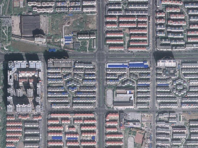
China’s biggest ghost city: Zhengzhou New District. This $19 billion development is packed with blocks of empty houses. businessinsider.com
Photo gallery: Satellite images of the ghost cities of China — 
An image from the European Space Agency’s Envisat satellite, released 24 July 2010, shows a vast blue-green algae bloom filling the Baltic Sea. Scientists say the potentially toxic bloom could pose a risk to marine life in the region.
Eutrophication makes toxic cyanobacteria more toxic — 
Cerro de Pasco mine, Peru. Greg Hayes
Open pit mine devours Peru town — 
British Columbia forest killed by pine beetle infestation. Photo by Lorraine Maclauchlan, Ministry of Forests, Southern Interior Forest Region
Pine beetles transform B.C. forests into net carbon emitters — 
Forest infested by Mountain Pine Beetle (red-brown area) near 100 Mile House, Cariboo-Chilcotin, British Columbia. shim.bc.ca
Risk of beetle outbreaks rise, along with temperature, in the warming West —

An isolated remnant of an ice spire in the crater of Mount Kilimanjaro in Tanzania. (Lonnie Thompson, Ohio State University)
Historic drought spurs life-or-death struggles in Kilimanjaro’s shadow — 
Retreat of Crane Glacier after collapse of the Larsen B ice shelf, Antarctica. NASA images by Robert Simmon based on Landsat-7 data.
Dramatic glacial retreat caught by NASA satellite —

Dust on top of snowpack, such as in the Red Mountain Pass area, increases the solar radiation on the surface, which results in faster melting. That has myriad effects on outdoor activities. The problem this year is worse than usual. Chris Landry / Center for Snow and Avalanche Studies
Dust hastens Colorado River snowmelt, cuts flow — 
Walruses haul-out along Alaska’s shoreline of the Chukchi Sea due to absence of sea ice, September 2010. Source: USGS
Tens of thousands of walruses concentrating along Alaska’s shore as sea ice vanishes — 
Asian carp jumping out of the Illinois River near Havana, IL. JasonLindsey.com
Officials poisoned Illinois river against advice of scientist — 
The divine Seba Blanchard helps to promote Desdemona, after a smoking-hot performance at Seattle Center with her troupe, WildCard BellyDance.


The Seba warming is the most powerful I have experienced.
I want to see the dance of doom.
Amazing images.
Thanks for all your work, Jim and company!
Impressive collection. Thanks.