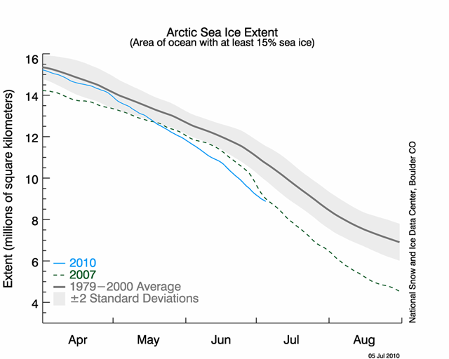
NSIDC: June Arctic sea ice saw lowest extent and fastest rate of decline in the satellite record
This year will almost certainly set the record for lowest Arctic ice volume ever recorded (see “When things were rotten“). But whether it will set the less important — but more visible — record for sea ice extent is less certain. You can see how close 2010 is to 2007 now. On the one hand, the National Snow and Ice Data Center just issued their July report, which notes, “June saw the return of the Arctic dipole anomaly, an atmospheric pressure pattern that contributed to the record sea ice loss in 2007.” On the other hand, they point out:
… it would not be surprising to see the rate of ice loss slow in coming weeks as the melt process starts to encounter thicker, second and third year ice in the central Arctic Ocean. Loss of ice has already slowed in the Beaufort and Chukchi Seas due to the tongue of thicker, older ice in the region noted in our April update.
Here is more on the dipole:
The record low ice extent of September 2007 was influenced by a persistent atmospheric pressure pattern called the summer Arctic dipole anomaly (DA). The DA features unusually high pressure centered over the northern Beaufort Sea and unusually low pressure centered over the Kara Sea, along the Eurasian coast. In accord with Buys Ballot’s Law, this pattern causes winds to blow from the south along the Siberian coast, helping to push ice away from the coast and favoring strong melt. The DA pattern also promotes northerly winds in the Fram Strait region, helping to flush ice out of the Arctic Ocean into the North Atlantic. The DA pattern may also favor the import of warm ocean waters from the North Pacific that hastens ice melt. June 2010 saw the return of the DA, but with the pressure centers shifted slightly compared to summer 2007. As a result, winds along the Siberian coastal sector are blowing more from the east rather than from the south. Whether or not the DA pattern persists through the rest of summer will bear strongly on whether a new record low in ice extent is set in September 2010. …
NSIDC: In June, Arctic sea ice saw lowest extent and fastest rate of decline in the satellite record
