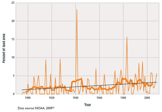
Graph of the Day: Abnormally High Annual Precipitation in the Lower 48 States, 1895–2008
This figure shows the percentage of the land area of the lower 48 states that experienced much greater than normal precipitation in any given year, which means it scored 2.0 or above on the annual Standardized Precipitation Index (SPI). The thicker orange line shows a nine-year moving average that smooths out some of the year-to-year fluctuations, while the straight black line is the trend line that fits the data best. • In recent years, a larger percentage of precipitation has come in the form of intense single-day events. Eight of the top 10 years for extreme one-day precipitation events have occurred since 1990. • The prevalence of extreme single-day precipitation events remained fairly steady between 1910 and the 1980s, but has risen substantially since then. Over the entire period from 1910 to 2008, the prevalence of extreme single-day precipitation events increased at a rate of about half a percentage point per decade (5 percentage points per century). • The percentage of land area experiencing much greater than normal yearly precipitation totals increased between 1895 and 2008. However, there has been much year-to-year variability. In some years there were no abnormally wet areas, while a few others had abnormally high precipitation totals over 10 percent or more of the lower 48 states’ land area. • Figures 1 and 2 are both consistent with a variety of other studies that have found an increase in heavy precipitation over timeframes ranging from single days to 90-day periods to whole years.
