Tennessee’s 1000-year flood: Rainfall at 15 sites exceeded Hurricane Katrina maxima
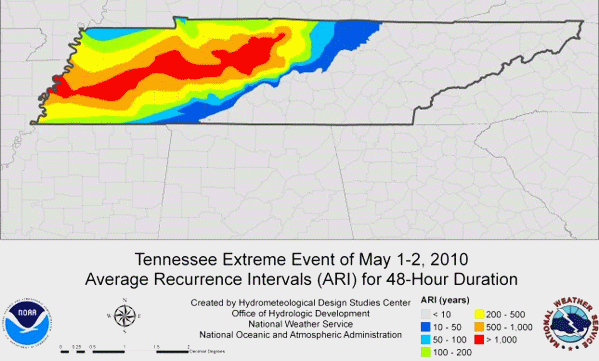
What is a 100 year flood? A 100 year flood is an event that statistically has a 1% chance of occurring in any given year. A 500 year flood has a .2% chance of occurring and a 1000 year flood has a .1% chance of occurring. The map below relates [the] amount of rainfall that fell to the chances of that amount of rain actually occurring. Climate Progress has been documenting the woefully underreported Tennessee deluge of 2010 aka Nashville’s ‘Katrina’. It was an off-the-charts extreme weather event that human-caused global warming set the table for and almost certainly made more intense, as a leading climate scientist explained to me (interview to be posted next week). But I didn’t understand just how unprecedented this superstorm was until I saw the above map from the Office of Hydrological Development at NOAA/NWS. I have never seen a map like this before, but then that may be because there simply aren’t many events to rival this one. Look at the red streak, which is the area hit by a greater than 1000-year deluge. And look at how much of western Tennessee was slammed with a greater than 500 year downpour. This is the “high water” of Hell and High Water. The NWS has more maps that put the deluge in perspective, including how it compared to Hurricane Katrina’s rainfall:
 Stunning NOAA map of Tennessee’s 1000-year deluge – 15 sites had rainfall exceeding maximum associated with Hurricane Katrina landfall
