Hurricane forecasters expect the worst in 2010 Atlantic season
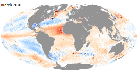
By Brian K. Sullivan May 4 (Bloomberg) — The 2010 Atlantic hurricane season may rival some of the worst in history as meteorological conditions mirror 2005, the record-breaking year that spawned New Orleans- wrecking Katrina, forecasters say. The El Nino warming in the Pacific is fading and rain is keeping dust down in Africa, cutting off two phenomena that help retard Atlantic hurricane formation. Perhaps most significantly, sea temperatures from the Cape Verde Islands to the Caribbean, where the storms usually develop, are above normal and reaching records in some areas. “We have only seen that in three previous seasons, 2005, 1958 and 1969, and all three of those years had five major hurricanes,” said Jeff Masters, co-founder of Weather Underground Inc. “I am definitely thinking that this is going to be a severe hurricane season.” With less than a month to go before the official June 1 start of the season, predictions are for 14 to 18 named storms. In an average year, there are 11 named storms with winds of at least 39 mph (62 kph), six of them reaching the 74-mph threshold for hurricanes and two growing into major storms with winds of 111 mph or more, the National Hurricane Center says. …
Hurricane Forecasters See Worst Looming in 2010 Atlantic Season
