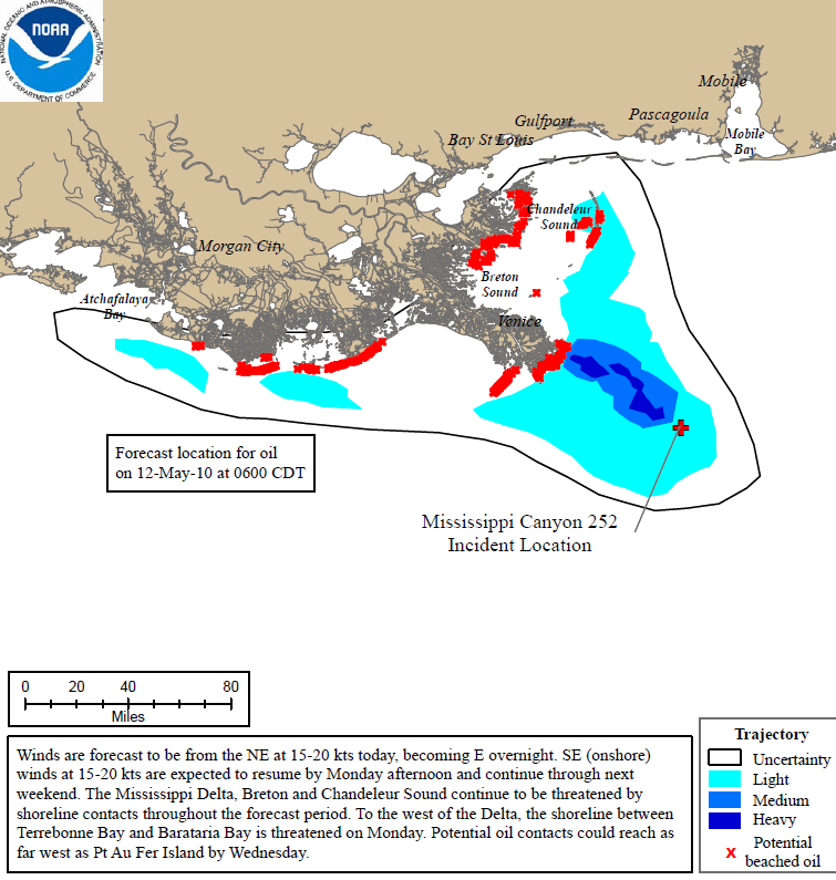
Graph of the Day: Projected Oil Spill Path to 12 May 2010
The experimental containment dome was successfully positioned over the leaking riser pipe last night, but then had to be removed after a large volume of ice-like methane hydrate crystals accumulated inside of the structure. These crystal hydrates blocked the flow of oil and threatened to lift the dome off the sea floor. The 4-story containment structure now sits on the seafloor next to the leak while experts consider ways to solve this issue. The emergency relief well progress continues and a second well is planned to start next week. To date over 910,000 feet of boom have been placed, another 1.3 million feet have been staged, approximately 2.1 million gallons of oil and water mix have been recovered, and 290,000 gallons of dispersant have been applied to the spilled oil. NOAA continues to track the floating oil with aircraft and satellite imagery. Twice daily, NOAA oceanographers continue to release updated trajectory maps showing the predicted trajectory of the oil slick. Winds are forecast to have an easterly component from Sunday through Monday. Mississippi Delta, Breton Sound and Chandeleur Sound continue to be threatened by oil contact with shorelines throughout the forecast period. The westerly movement of the oil is expected to continue though the forecast period with the western edge nearing Atchafalaya Bay on Monday. NOAA efforts have included modeling the trajectory and extent of the oil; getting pre-impact samples, surveys, and baseline measurements; planning for open water and shoreline remediation; supporting the Unified Command as it analyzes new techniques for handling the spill; and starting Natural Resource Damage Assessments (NRDA).
