May 6, 2010
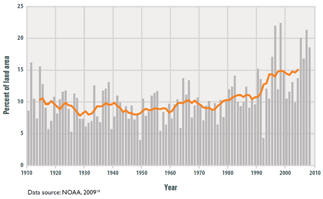
Graph of the Day: Extreme One-Day Precipitation Events in the Lower 48 States, 1910–2008
This figure shows the percentage of the land area of the lower 48 states where a much greater than normal portion of total annual precipitation has come from extreme single-day precipitation events. The bars represent individual years, while the line is a smoothed nine-year moving average.
- In recent years, a larger percentage of precipitation has come in the form of intense single-day events. Eight of the top 10 years for extreme one-day precipitation events have occurred since 1990.
- The prevalence of extreme single-day precipitation events remained fairly steady between 1910 and the 1980s, but has risen substantially since then. Over the entire period from 1910 to 2008, the prevalence of extreme single-day precipitation events increased at a rate of about half a percentage point per decade (5 percentage points per century).
- The percentage of land area experiencing much greater than normal yearly precipitation totals increased between 1895 and 2008. However, there has been much year-to-year variability. In some years there were no abnormally wet areas, while a few others had abnormally high precipitation totals over 10 percent or more of the lower 48 states’ land area.
- Figures 1 and 2 are both consistent with a variety of other studies that have found an increase in heavy precipitation over timeframes ranging from single days to 90-day periods to whole years.
