Eating Appalachia: NASA satellite images reveal mountain cannibalism for coal
www.mongabay.com
March 02, 2010 Eating a mountain for coal New images released by NASA reveal the conversion of mountains and forests in southern West Virginia to a giant surface mine.
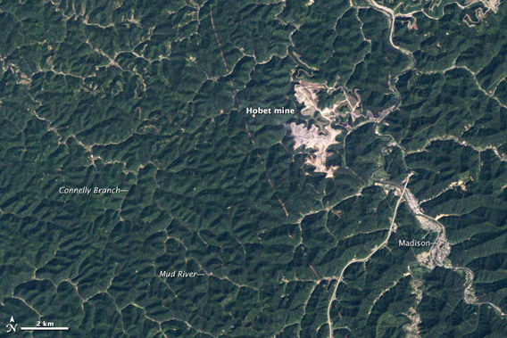
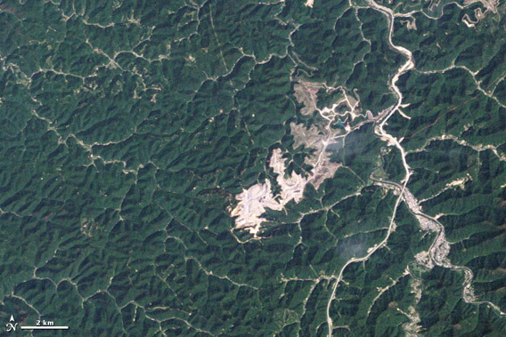
The time-lapse shots from 1984 to 2009 show the process of mountaintop removal in Boone County, West Virginia. The images show forests being stripped, valleys filled, and giant craters excavated in the process of mining thin seams of coal at Hobet mine.
“These natural-color (photo-like) images document the growth of the Hobet mine as it moves from ridge to ridge between 1984 to 2009,” states NASA’s Earth Observatory.
The mine area would grow to more than 10,000 acres over the life of the photo series, which is based on data from NASA’s Landsat 5 satellite.
NASA’s Earth Observatory describes the images:The natural landscape of the area is dark green, forested mountains, creased by streams and indented by hollows. The active mining areas appear off-white, while areas being reclaimed with vegetation appear light green. A pipeline roughly bisects the images from north to south. The town of Madison, lower right, lies along the banks of the Coal River.
In 1984, the mining operation is limited to a relatively small area west of the Coal River. The mine first expands along mountaintops to the southwest, tracing an oak-leaf-shaped outline around the hollows of Big Horse Creek and continuing in an unbroken line across the ridges to the southwest. Between 1991 and 1992, the mine moves north, and the impact of one of the most controversial aspects of mountaintop mining—rock and earth dams called valley fills—becomes evident. …
(click below to see 1992 – 2009 images)
Eating Appalachia: NASA satellite images reveal mountain cannibalism for coal

