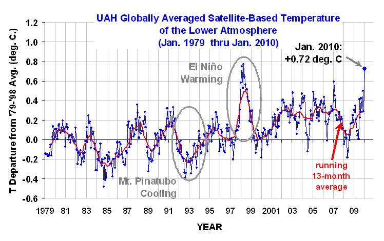
Graph of the Day: UAH Globally Averaged Satellite-Based Temperature of the Lower Atmosphere, Jan 1979 – Jan 2010
From Climate Progress: Yes, the mid-Atlantic region appears headed toward an epic snow storm as “amazing moisture feeds into what is already a gigantic system,” according to the Capital Weather Gang. But while the anti-science crowd will no doubt tout that as evidence we aren’t warming — just as they did with the “cold snap” in early January — in fact, climate science predicts we will see more extreme precipitation events year-round as warming puts more moisture into the atmosphere [see Was the “Blizzard of 2009″ a “global warming type” of record snowfall — or an opportunity for the media to blow the extreme weather story (again)?]. Indeed, the January “cold snap” not only didn’t prove the case for (nonexistent) global cooling — it turns out that January was uber-hot around the globe! As leading anti-science guy Roy Spencer posted Thursday (including the figure above):
The global-average lower tropospheric temperature anomaly soared to +0.72 deg. C in January, 2010. This is the warmest January in the 32-year satellite-based data record…. Note the global-average warmth is approaching the warmth reached during the 1997-98 El Nino, which peaked in February of 1998.
Of course, right now we’re only in a moderate El Nino. In 97-98, we had a monster El Nino. And Spencer doesn’t mention that this record is especially impressive because we’re at “the deepest solar minimum in nearly a century.” The point is, notwithstanding the all-too-effective disinformation campaign of the anti-science crowd, it’s getting hotter — thanks primarily to human emissions. The satellite record itself clearly shows the long-term warming trend, especially when you remove the stratospheric cooling influences. …
Human-caused global warming easily overwhelms much-hyped “cold snap”
