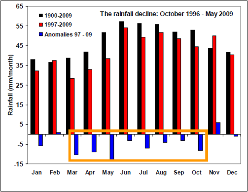
Graph of the Day: Australia Rainfall Decline, October 1996 – May 2009
Monthly mean SEA rainfall for the long-term climatology (black bars), for the ongoing protracted drought (red bars); changes from the long term climatology are shown as blue bars. The continuous months with negative rainfall anomalies are outlined with the orange box. The long-term rainfall deficiency since October 1996 across South Eastern Australia (south of 33.5ºS and east of 135.5ºE) documented by MT08 was described as being severe but not unprecedented in the instrumental record. With an additional 3 years of below average rainfall, that statement is no longer true. The recent 12 year, 8 month period is the driest in the 110 years long record, surpassing the previous driest period during WWII. The spatial extent of the deficiency covers most of the south-western part of eastern Australia and extends along significant orographic features eastward and northward. The seasonal signature of the rainfall decline has also evolved. It remains dominated by a strong and highly significant autumn rainfall decline, but has been supplemented by recent declines in spring, particularly after 2002. The spring decline is the dominant feature of the very dry 2006-2008 period. This change in the relative contributions by the autumn and spring seasons now more closely resembles the picture provided by climate model simulations of future changes due to enhanced greenhouse gases. However, the growing magnitude of the rainfall decline is far more severe than any of the IPCC-AR4 model projections except for the lowest deciles from the model uncertainty range, forced with the highest emission scenarios occurring later in the 21st century (2050 to 2070) (CSIRO and Bureau of Meteorology, 2007).
Timbal, B., The continuing decline in South-East Australian rainfall — Update to May 2009, CAWCR Research Letters Issue 2, July 2009, [pdf] via Brave New Climate
